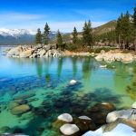
he Americas, which are sometimes collectively called America, are a landmass comprising the totality of North and South America. The Americas make up most of the land in Earth’s Western Hemisphere and comprise the New World.
Along with their associated islands, the Americas cover 8% of Earth’s total surface area and 28.4% of its land area. The topography is dominated by the American Cordillera, a long chain of mountains that runs the length of the west coast. The flatter eastern side of the Americas is dominated by large river basins, such as the Amazon, St. Lawrence River–Great Lakes basin, Mississippi, and La Plata. Since the Americas extend 14,000 km (8,700 mi) from north to south, the climate and ecology vary widely, from the arctic tundra of Northern Canada, Greenland, and Alaska, to the tropical rain forests in Central America and South America.
Humans first settled the Americas from Asia between 42,000 and 17,000 years ago. A second migration of Na-Dene speakers followed later from Asia. The subsequent migration of the Inuit into the neoarctic around 3500 BCE completed what is generally regarded as the settlement by the indigenous peoples of the Americas.
1.Grand Canyon
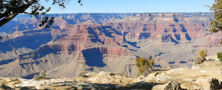
Grand Canyon National Park, in Arizona, is home to much of the immense Grand Canyon, with its layered bands of red rock revealing millions of years of geological history. Viewpoints include Mather Point, Yavapai Observation Station and architect Mary Colter’s Lookout Studio and her Desert View Watchtower. Lipan Point, with wide views of the canyon and Colorado River, is a popular, especially at sunrise and sunset.
Grand Canyon National Park is one of the world’s premier natural attractions, attracting about five million visitors per year. Overall, 83% were from the United States: California (12%), Arizona (9%), Texas (5%), Florida (3%) and New York (4%) represented the top domestic visitors. Seventeen percent of visitors were from outside the United States; the most prominently represented nations were the United Kingdom (3%), Canada (4%), Japan (2%), Germany (2%) and the Netherlands (1%). The South Rim is open all year round weather permitting. The North Rim is generally open mid-May to mid-October.
2.Niagara Falls
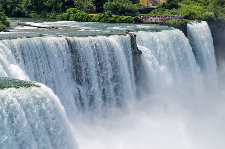
Niagara Falls, Ontario, is a Canadian city at the famous waterfalls of the same name, linked with the U.S. by the Rainbow Bridge. Its site on the Niagara River’s western shore overlooks the Horseshoe Falls, the cascades’ most expansive section. Elevators take visitors to a lower, wetter vantage point behind the falls. A cliffside park features a promenade alongside 520-ft.-high Skylon Tower with an observation deck.
Formed by the Niagara River, which drains Lake Erie into Lake Ontario, the combined falls have the highest flow rate of any waterfall in North America that has a vertical drop of more than 50 m (160 ft). During peak daytime tourist hours, more than 168,000 m3 (5.9 million cu ft) of water goes over the crest of the falls every minute.Horseshoe Falls is the most powerful waterfall in North America, as measured by flow rate. Niagara Falls is famed for its beauty and is a valuable source of hydroelectric power. Balancing recreational, commercial, and industrial uses has been a challenge for the stewards of the falls since the 19th century.
Niagara Falls is 27 km (17 mi) northwest of Buffalo, New York, and 69 km (43 mi) southeast of Toronto, between the twin cities of Niagara Falls, Ontario, and Niagara Falls, New York. Niagara Falls was formed when glaciers receded at the end of the Wisconsin glaciation (the last ice age), and water from the newly formed Great Lakes carved a path over and through the Niagara Escarpment en route to the Atlantic Ocean.
3.Statue of Liberty
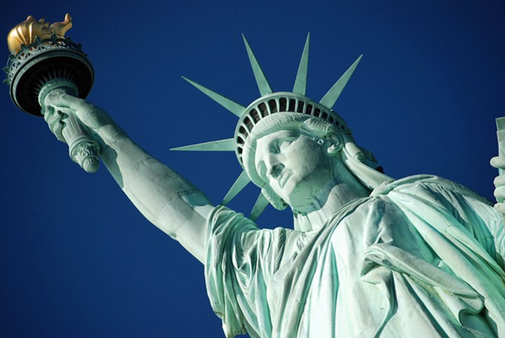
he Statue of Liberty is a colossal neoclassical sculpture on Liberty Island in New York Harbor in New York City, in the United States.
The statue is a figure of Libertas, a robed Roman liberty goddess. She holds a torch above her head with her right hand, and in her left hand carries a tabula ansata inscribed JULY IV MDCCLXXVI (July 4, 1776 in Roman numerals), the date of the U.S. Declaration of Independence. A broken shackle and chain lie at her feet as she walks forward, commemorating the recent national abolition of slavery. After its dedication, the statue became an icon of freedom and of the United States, seen as a symbol of welcome to immigrants arriving by sea.
Bartholdi was inspired by a French law professor and politician, Édouard René de Laboulaye, who is said to have commented in 1865 that any monument raised to U.S. independence would properly be a joint project of the French and American peoples. The Franco-Prussian War delayed progress until 1875, when Laboulaye proposed that the French finance the statue and the United States provide the site and build the pedestal. Bartholdi completed the head and the torch-bearing arm before the statue was fully designed, and these pieces were exhibited for publicity at international expositions.
A universal symbol of freedom, the Statue of Liberty is America’s most familiar icon and the largest statue in the world. Standing proudly in New York Harbor, visitors can admire the statue from various points around the city, particularly Battery Park, or take a ferry right to the statue.
For people who plan to go out to the statue, options include grounds tickets, pedestal tickets, or crown tickets, which allow different levels of access to the site. One of the best options is to take a sightseeing tour and see both the Statue of Liberty and Ellis Island.
4.Walt Disney World Resort

The Walt Disney World Resort, also called Walt Disney World or simply Disney World, is an entertainment resort complex in Bay Lake and Lake Buena Vista, Florida, United States, near the cities of Orlando and Kissimmee.
This mega amusement park in Orlando is the top family attraction in America, and has been catering to both young and old for decades. Opened in 1971, Walt Disney World has managed to maintain its relevance and its allure for children and even many adults throughout the years.
Walt Disney World Resort encompasses not only the various theme parks, it also includes water parks, Downtown Disney with shopping and theaters, and much more, from fine dining to golf. This is a place where you can spend a day or a week.
Opened on October 1, 1971, the resort is operated by Disney Parks, Experiences and Products, a division of The Walt Disney Company. The property covers nearly 25,000 acres (39 sq mi; 101 km2), of which half has been used.[5] The resort comprises four theme parks (Magic Kingdom, Epcot, Disney’s Hollywood Studios, and Disney’s Animal Kingdom), two water parks (Disney’s Blizzard Beach and Disney’s Typhoon Lagoon), 31 themed resort hotels, nine non-Disney hotels, several golf courses, a camping resort, and other entertainment venues, including the outdoor shopping center Disney Springs.
5.Waikiki
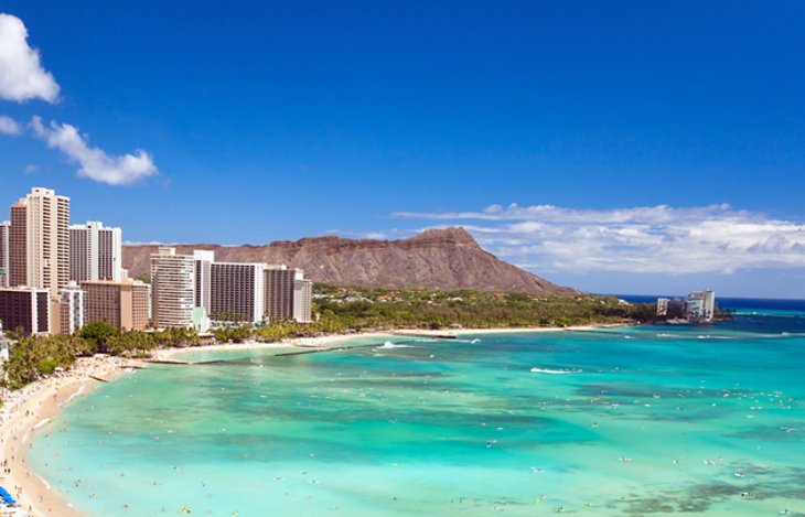
High-rise hotels line the shore in Waikiki, a vibrant neighborhood known for its popular surf beach. Designer fashion stores line Kalakaua Avenue and nearby streets, and the area buzzes after dark with waterside cocktail bars, fine dining and Kuhio Beach hula shows. Honolulu Zoo is home to Komodo dragons and wandering peacocks, while parrotfish and urchins inhabit Waikiki Aquarium’s reef exhibit.
Waikiki is home to public places including Kapiʻolani Park, Fort DeRussy, Kahanamoku Lagoon, Kūhiō Beach Park and Ala Wai Harbor. Waikiki[a] was the first capital of the Kingdom of Hawaii from 1795 to 1796.
Waikiki beach has had repeated problems with erosion, leading to the construction of groins and beach replenishment projects. Imported sand came from California and from local beaches such as Pāpōhaku Beach on Moloka‘i, and a sandbar from Oʻahu’s Northern side near Kahuku. Officials look for ways to sustain the existing sand by eliminating loss due to tidal flow.
Erosion claims about one foot (0.3 m) of beach per year.
6.Las Vegas Strip
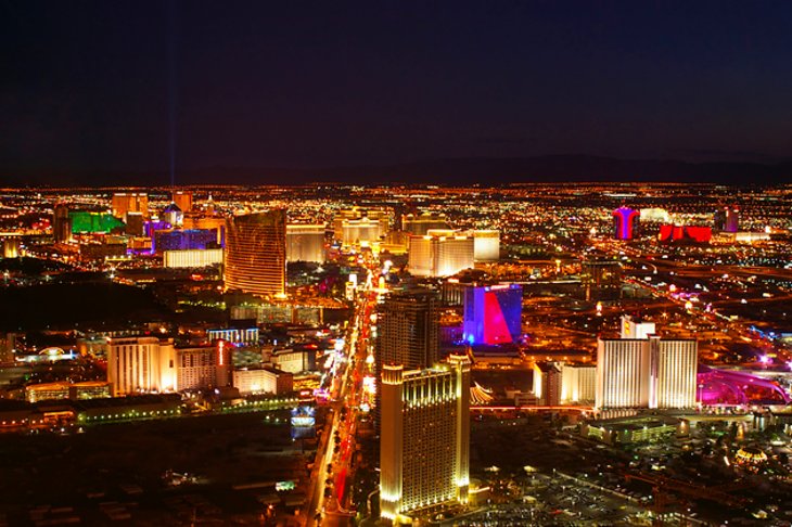
Lined with upscale casino hotels, the neon-soaked Strip is quintessential Las Vegas. As well as gambling floors, the vast hotel complexes house a variety of shops, restaurants (ranging from mainstream to high-end), and performance venues for music, comedy and circus-style acts. Attractions like the soaring, choreographed Fountains of Bellagio and the High Roller observation wheel draw crowds.
Historically, casinos that were not in Downtown Las Vegas along Fremont Street sat outside the city limits on Las Vegas Boulevard. In 1959, the Welcome to Fabulous Las Vegas sign was built exactly 4.5 miles (7.2 km) outside the city limits. The sign is currently located in the median just south of Russell Road, across from the location of the now-demolished Klondike Hotel and Casino and about 0.4 miles (0.64 km) south of the southernmost entrance to Mandalay Bay, which is the Strip’s southernmost casino.
In the strictest sense, “the Strip” refers only to the stretch of Las Vegas Boulevard that is roughly between Sahara Avenue and Russell Road, a distance of 4.2 miles (6.8 km). Clark County uses the phrase Resort Corridor to describe the area including Las Vegas Boulevard between 215 Beltway and Sahara Avenue and surrounding areas.
Beginning at one end with the Luxor Hotel, designed in a pyramid shape, a walk down the street will reveal an erupting volcano and dancing fountains, while inside the resorts are all kinds of oddities and entertainment. Many of the best things to see and do in Las Vegas are sights that can be seen for free.
7.Yosemite National Park
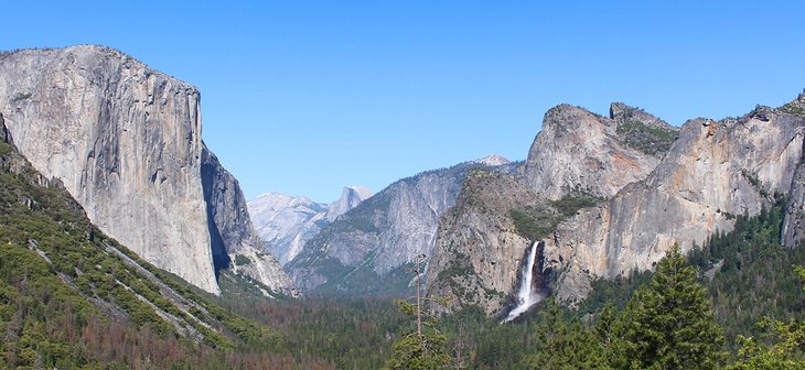
Yosemite National Park is in California’s Sierra Nevada mountains. It’s famed for its giant, ancient sequoia trees, and for Tunnel View, the iconic vista of towering Bridalveil Fall and the granite cliffs of El Capitan and Half Dome. In Yosemite Village are shops, restaurants, lodging, the Yosemite Museum and the Ansel Adams Gallery, with prints of the photographer’s renowned black-and-white landscapes of the area.
European American settlers first entered Yosemite Valley itself in 1851. There are earlier instances of other travelers entering the Valley but James D. Savage is accredited with discovering the area that is now known as Yosemite National Park. Despite Savage and other white men claiming their discovery of Yosemite, the region and Valley itself has been inhabited for nearly 4,000 years, although humans may have first visited the area as long as 8,000 to 10,000 years ago.
Yosemite was critical to the development of the national park idea. Galen Clark and others lobbied to protect Yosemite Valley from development, ultimately leading to President Abraham Lincoln signing the Yosemite Grant of 1864 which declared Yosemite as federally preserved land. It was not until 1890 when John Muir led a successful movement which had Congress establish Yosemite Valley and its surrounding areas as a National Park. This helped pave the way for the National Park System.Yosemite now draws about four million visitors each year, and most visitors spend the majority of their time in the seven square miles (18 km2) of Yosemite Valley.The park set a visitation record in 2016, surpassing five million visitors for the first time in its history. The park began requiring reservations to access the park during peak periods starting in 2020 as a response to the rise in visitors.
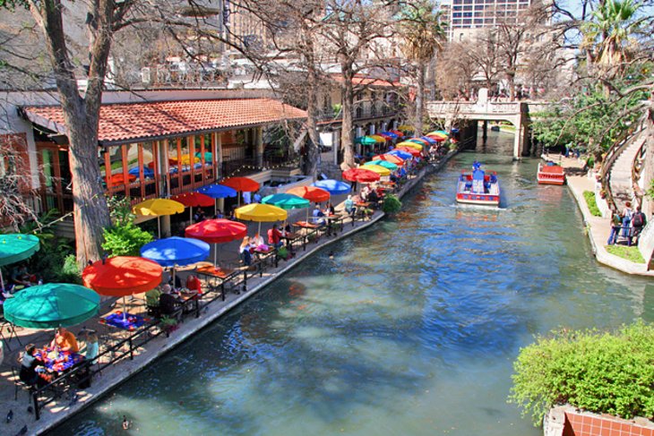
8.San Antonio River Walk
The San Antonio River Walk is a city park and special-case pedestrian street in San Antonio, Texas, one level down from the automobile street.
The San Antonio River Walk is a city park and special-case pedestrian street in San Antonio, Texas, one level down from the automobile street. The River Walk winds and loops under bridges as two parallel sidewalks lined with restaurants and shops, connecting the major tourist draws such as the Shops at Rivercenter, the Arneson River Theatre, Marriage Island, La Villita, HemisFair Park, the Tower Life Building, the San Antonio Museum of Art, the Pearl, and the city’s five Spanish colonial missions, which have been named a World Heritage Site, which includes the Alamo. During the annual springtime Fiesta San Antonio, the River Parade features flowery floats that float down the river.
The area within the circumference of the River Walk is the heart of the original 1700s Villa de Bejar outpost, which would eventually become the City of San Antonio.
Small boats meander along the river and scenic arching bridges complete the tranquil scene. Large old trees drape over the river and walkway providing shade. The River Walk also features a variety of entertainment, with occasional live music and seasonal events.