Canada is a country in North America. Its ten provinces and three territories extend from the Atlantic Ocean to the Pacific Ocean and northward into the Arctic Ocean, covering over 9.98 million square kilometres, making it the world’s second-largest country by total area.
Indigenous peoples have continuously inhabited what is now Canada for thousands of years. Beginning in the 16th century, British and French expeditions explored and later settled along the Atlantic coast. As a consequence of various armed conflicts, France ceded nearly all of its colonies in North America in 1763. In 1867, with the union of three British North American colonies through Confederation, Canada was formed as a federal dominion of four provinces. This began an accretion of provinces and territories and a process of increasing autonomy from the United Kingdom. This widening autonomy was highlighted by the Statute of Westminster 1931 and culminated in the Canada Act 1982, which severed the vestiges of legal dependence on the Parliament of the United Kingdom.
Canada is a parliamentary democracy and a constitutional monarchy in the Westminster tradition. The country’s head of government is the prime minister—who holds office by virtue of their ability to command the confidence of the elected House of Commons—and is appointed by the governor general, representing the monarch, who serves as head of state. The country is a Commonwealth realm and is officially bilingual (English and French) at the federal level. It ranks among the highest in international measurements of government transparency, civil liberties, quality of life, economic freedom, education, gender equality and environmental sustainability. It is one of the world’s most ethnically diverse and multicultural nations, the product of large-scale immigration. Canada’s long and complex relationship with the United States has had a significant impact on its economy and culture.
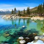
1.Gros Morne National Park
Gros Morne National Park lies on the west coast of the island of Newfoundland, in eastern Canada. Gros Morne, a peak in the Long Range Mountains, has a trail overlooking the Ten Mile Pond gorge. Western Brook Pond, a fjord formed by glaciers, is lined with cliffs and waterfalls, including Pissing Mare Falls. The desert-like Tablelands area has unusual rock formations created by the earth’s tectonic plates colliding.
The park takes its name from Newfoundland’s second-highest mountain peak (at 806 m or 2,644 ft) located within the park. Its French meaning is “large mountain standing alone,” or more literally “great sombre.” Gros Morne is a member of the Long Range Mountains, an outlying range of the Appalachian Mountains, stretching the length of the island’s west coast. It is the eroded remnants of a mountain range formed 1.2 billion years ago. In 1987, the park was awarded World Heritage Site status by UNESCO because “The park provides a rare example of the process of continental drift, where deep ocean crust and the rocks of the earth’s mantle lie exposed.”
The Gros Morne National Park Reserve was established in 1973, and was made a national park on October 1, 2005.
The park’s rock formations, made famous by Robert Stevens and Harold Williams, include oceanic crust and mantle rock exposed by the obduction process of plate tectonics, as well as sedimentary rock formed during the Ordovician, Precambrian granite and Palaeozoic igneous rocks.
The park is located in the Great Northern Peninsula of Western Newfoundland. This peninsula is referred to as the Humber Zone, a Miogeocline, the Highlands of which contain the largest external basement massif of the Grenville Orogeny in the Appalachian Orogen. This Precambrian basement is known as the Long Range Inlier, Long Range Complex or Basement Gneiss Complex, consisting of quartz-feldspar gneisses and granites that are up to 1550 Ma in age. Mt. Gros Morne and Mt. Big Level lie within this Inlier. The western boundary of this inlier (along Western Brook Pond, St. Pauls Inlet, and south of Portl Creek Pond) consists of Devonian and Ordovician thrust faults, where crystalline rocks thrust over Cambrian-Ordovician carbonate rocks and the Lower Paleozoic Humber Arm Allochthon.
2.Calgary Stampede

Organized by thousands of volunteers and supported by civic leaders, the Calgary Stampede has grown into one of the world’s richest rodeos, one of Canada’s largest festivals, and a significant tourist attraction for the city. Rodeo and chuckwagon racing events are televised across Canada. However, both have been the target of increasing international criticism by animal welfare groups and politicians concerned about particular events as well as animal rights organizations seeking to ban rodeo in general.
Calgary’s national and international identity is tied to the event. It is known as the “Stampede City”, carries the informal nickname of “Cowtown”, and the local Canadian Football League team is called the Stampeders. The city takes on a party atmosphere during Stampede: office buildings and storefronts are painted in cowboy themes, residents don western wear, and events held across the city include hundreds of pancake breakfasts and barbecues.
The parade serves as the official opening of the Stampede and begins shortly before 9 a.m. on the first Friday of the event. Each year features a different parade marshal, chosen to reflect the public’s interests at that time. Politicians, athletes, actors and other dignitaries have all served as marshals.The event features dozens of marching bands, over 150 floats and hundreds of horses with entrants from around the world, and combines western themes with modern ones. Cowboys, First Nations dancers and members of the Royal Canadian Mounted Police in their red serges are joined by clowns, bands, politicians and business leaders.
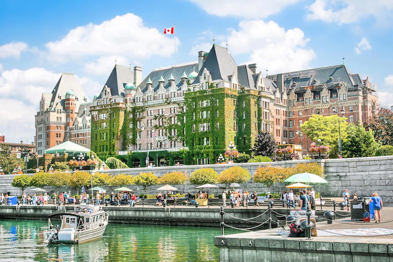
3.Victoria’s Inner Harbour
Before European development the Coast Salish Songhees people lived in settlements to the east of the harbour and the Esquimalt people lived to the west of it. They cultivated camas root and other crops in meadows lined with cultivated Garry oak trees along the harbour.Shell middens along the Gorge Waterway are evidence of human habitation dating back 4000 years.
Victoria’s Inner Harbour on Vancouver Island is a cool place to visit. There’s the water on one side and stately government buildings on the other since Victoria is the capital of British Columbia. The city hosts a classic boat festival on Labour Day in September, with the harbor filling up with wooden boats.
Visitors can also navigate the harbor on kayaks or tour boats. Take time out to have a traditional British tea at the Empress Hotel, a Victoria landmark since the early 1900s; it’s right across from the harbor.
4.Bay of Fundy
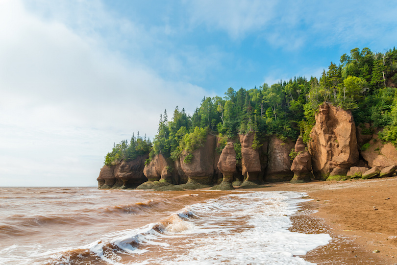
The Bay of Fundy lies between Canada’s Nova Scotia and New Brunswick provinces, and touches the U.S. state of Maine. It’s known for extremely high tides, as at spots like New Brunswick’s Hopewell Rocks. These eroded “flowerpot” formations stand in water or on dry land, depending on the time of day. The coastal Fundy Trail Parkway offers lookouts and beaches. Fundy National Park has trails through the Acadian Forest.
The tidal range in the Bay of Fundy is about 16 metres (52 ft); the average tidal range worldwide is only one metre (3.3 ft). Some tides are higher than others, depending on the position of the moon, the sun, and atmospheric conditions.Tides are semidiurnal, meaning they have two highs and two lows each day,with about six hours and 13 minutes between each high and low tide.
Because of tidal resonance in the funnel-shaped bay, the tides that flow through the channel are very powerful. In one 12-hour tidal cycle, about 100 billion tons (110 billion short tons) of water flows in and out of the bay, which is twice as much as the combined total flow of all the rivers of the world over the same period. The Annapolis Royal Generating Station, a 20 MW tidal power station on the Annapolis River upstream of Annapolis Royal, was one of the few tidal generating stations in the world, and the only one in North America.
5.Athabasca Falls
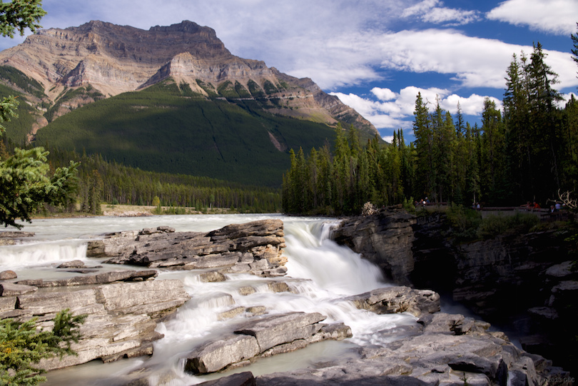
Athabasca Falls is a waterfall in Jasper National Park on the upper Athabasca River, approximately 30 kilometres south of the townsite of Jasper, Alberta, Canada, and just west of the Icefields Parkway.
Athabasca Falls is a Class 5 waterfall, with a total drop height of 24 m (79 ft) and a width of 46 m (151 ft). A powerful, picturesque waterfall, Athabasca Falls is not known so much for its height as for its force, due to the large quantity of water falling into the gorge, which can be substantial even on a cold morning in the fall, when river levels tend to be at their lowest. The river falls over a layer of hard quartzite and through the softer limestone below, carving a short gorge and a number of potholes.
Even when the water level in the upper Athabasca River is low, huge quantities of water pour over the falls. Several viewing platforms and trails where it is safe to photograph the picturesque scene are located around the falls. Motorists can cross over the falls by taking Highway 93A into the town of Jasper.
6.Churchill
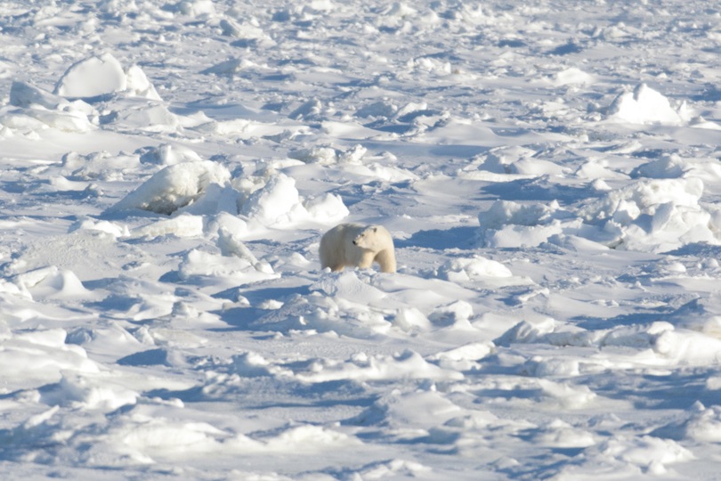
It may only be a small town of 1,000 residents in the Manitoba province on the Hudson Bay shore, but Churchill draws huge crowds every year to see its most famous inhabitants, the polar bears. Nicknamed the “Polar Bear Capital of the World,” it is one of the top tourist attractions in Canada. In addition to polar bears, Churchill is also a popular place for viewing beluga whales, birds and the aurora borealis.
7.The Canadian
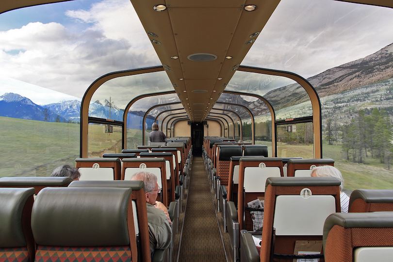
The Canadian is a transcontinental passenger train operated by Via Rail with service between Union Station in Toronto, Ontario and Pacific Central Station in Vancouver, British Columbia, Canada. Before 1955, the Canadian was a Canadian Pacific Railway train between Toronto and Chicago.
Before 1955, the Canadian was a Canadian Pacific Railway (CPR) train between Toronto and Chicago. On April 24, 1955, CPR renamed its best transcontinental train between Montreal/Toronto and Vancouver the Canadian, with new lightweight stainless-steel equipment. Via Rail Canada took over in 1978, and, on January 15, 1990, designated the Canadian as its sole transcontinental service, between Toronto and Vancouver-only. (Montreal-Sudbury-Vancouver through service, originally the main section of the train, was discontinued on this date). The new service replaced the former “Super Continental” CNR flagship passenger service, and continues to run as of 2022 primarily over Canadian National tracks.