Iceland, a Nordic island nation, is defined by its dramatic landscape with volcanoes, geysers, hot springs and lava fields. Massive glaciers are protected in Vatnajökull and Snæfellsjökull national parks. Most of the population lives in the capital, Reykjavik, which runs on geothermal power and is home to the National and Saga museums, tracing Iceland’s Viking history.
Iceland is the only part of the Mid-Atlantic Ridge that rises above sea level, and its central volcanic plateau is erupting almost constantly. The interior consists of a plateau characterised by sand and lava fields, mountains, and glaciers, and many glacial rivers flow to the sea through the lowlands. Iceland is warmed by the Gulf Stream and has a temperate climate, despite a high latitude just outside the Arctic Circle. Its high latitude and marine influence keep summers chilly, and most of its islands have a polar climate.
Until the 20th century, Iceland relied largely on subsistence fishing and agriculture. Industrialization of the fisheries and Marshall Plan aid following World War II brought prosperity, and Iceland became one of the wealthiest and most developed nations in the world. It became a part of the European Economic Area in 1994; this further diversified the economy into sectors such as finance, biotechnology, and manufacturing.
Swedish Viking explorer Garðar Svavarsson was the first to circumnavigate Iceland in 870 and establish that it was an island. He stayed during the winter and built a house in Húsavík. Garðar departed the following summer, but one of his men, Náttfari, decided to stay behind with two slaves. Náttfari settled in what is now known as Náttfaravík, and he and his slaves became the first permanent residents of Iceland to be documented.
1.Soak in the Blue Lagoon, Grindavík
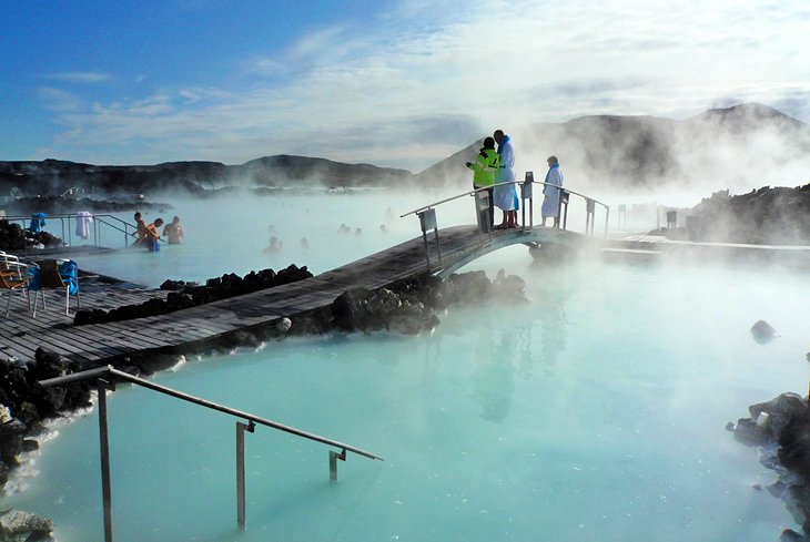
Grindavík is a fishing town on the Southern Peninsula of Iceland not far from the tuya Þorbjörn. It is one of the few cities with a harbour on this coast. Most of the inhabitants work in the fishing industry. The Blue Lagoon, Grindavík’s premiere attraction, is located 5 kilometres from the town centre.
A short distance to the north, there is the Blue Lagoon (Icelandic: Bláa Lónið), a geothermal spa using hot and mineralized waters from the nearby Svartsengi power station.
The Leif the Lucky Bridge spans the Álfagjá rift valley that marks the boundary of the Eurasian and North American continental tectonic plates. It was built in 2002 and named in honor of Icelandic explorer Leif Erikson, who travelled from Europe to explore North America 500 years before Columbus.
The Icelandic Saltfish Museum in Grindavík opened in 2002. It displays the story of salt fish production and its importance for the Icelandic economy throughout the centuries in a specially designed building of 650 square metres (7,000 sq ft).
The origins of the municipality can be traced to Einar Einarsson’s decision to move there to build and run a shop in 1897. During that time the population was only around 360. Fishing had for centuries been a crucial element in the survival of Grindavik’s population, but fishing trips were often dangerous. Men were frequently lost at sea and the catch not always stable. However, when a safer access point to land was created at Hópið in 1939, fishing conditions changed dramatically. From 1950 serious development in the fishing industry had begun to take place. Grindavik was declared a municipality in 1974.
2.Breidavik Beach
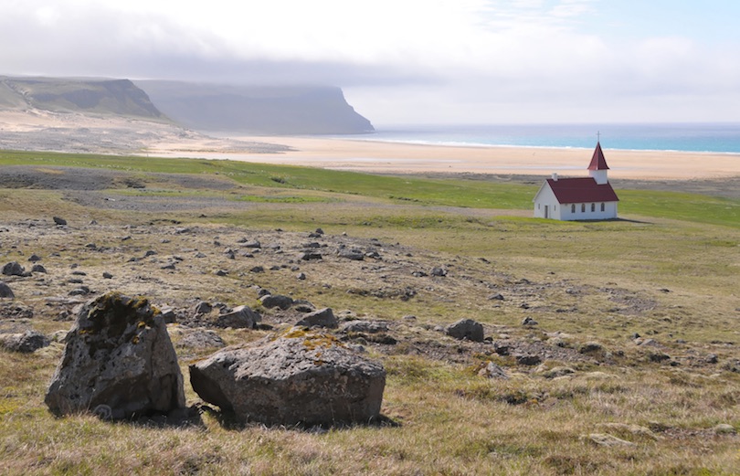
The pretty little settlement of Breiðavík is located just around the corner from Iceland’s (and Europe’s) most westerly point, Látrabjarg. Besides the weatherboard church and a clutch of houses there is one thing that draws people to Breidavik – the enormous stretch of white sand beach.
Breidavik Beach is said by many to be the finest beach in Iceland and it’s not difficult to see why. Breiðavík set on a meadow encompassed by the huge crescent of glacier carved cliffs of Bjarnamupur and the aquamarine waters of the Atlantic ocean. The beach here seems to go on for ever though it is occasionally interrupted by a mountain stream making its way down to the sea.
Unlike many of Iceland’s beaches, the sands here are golden, giving it an ambience that is differs from the rest of the country; in bright weather, it almost looks tropical. By the shore, there is a quaint church, and there are options for accommodation here in summer.
Staying in this area is excellent for birdwatchers who wish to see the millions of birds from dozens of species that nest and feed nearby, including puffins from May to August.
3.The Northern Lights, Aurora Borealis
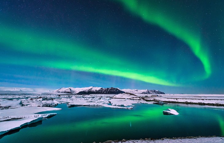
An aurora, also known as the polar lights or aurora polaris, is a natural light display in Earth’s sky, predominantly seen in high-latitude regions. Auroras display dynamic patterns of brilliant lights that appear as curtains, rays, spirals, or dynamic flickers covering the entire sky.
Auroras are the result of disturbances in the magnetosphere caused by the solar wind. These disturbances alter the trajectories of charged particles in the magnetospheric plasma. These particles, mainly electrons and protons, precipitate into the upper atmosphere (thermosphere/exosphere). The resulting ionization and excitation of atmospheric constituents emit light of varying colour and complexity. The form of the aurora, occurring within bands around both polar regions, is also dependent on the amount of acceleration imparted to the precipitating particles.
Most of the planets in the Solar System, some natural satellites, brown dwarfs, and even comets also host auroras.
Most auroras occur in a band known as the “auroral zone”, which is typically 3° to 6° wide in latitude and between 10° and 20° from the geomagnetic poles at all local times (or longitudes), most clearly seen at night against a dark sky. A region that currently displays an aurora is called the “auroral oval”, a band displaced by the solar wind towards the night side of Earth.Early evidence for a geomagnetic connection comes from the statistics of auroral observations. Elias Loomis (1860), and later Hermann Fritz (1881) and Sophus Tromholt (1881) in more detail, established that the aurora appeared mainly in the auroral zone.
4.Explore the Skaftafell Ice Cave, Vatnajökull National Park
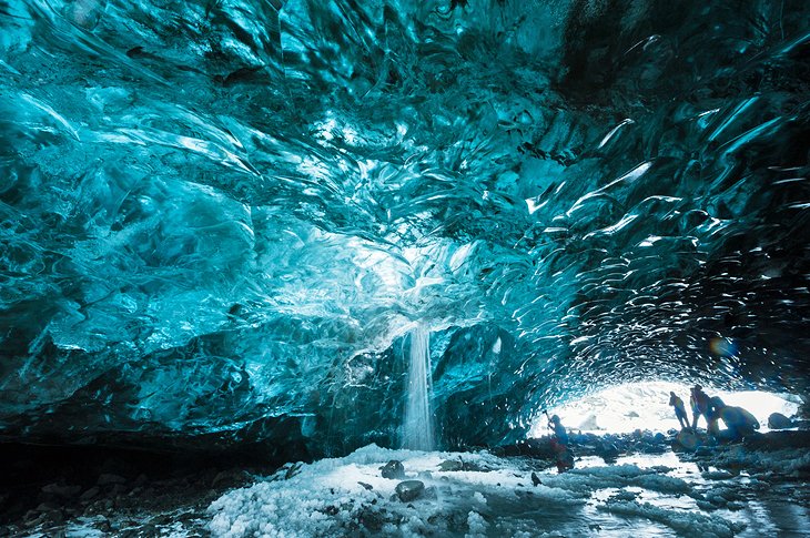
Vatnajökull National Park is a protected wilderness area in south Iceland centered around Vatnajökull glacier. Defined by massive glaciers, ice caves, snowy mountain peaks, active geothermal areas and rivers, the region includes Jökulsárlón, a glacial lagoon with icebergs, and the Svartifoss and Dettifosis waterfalls. Skaftafell is the gateway to the park with a visitor center, campground and hiking trails.
Vatnajökull is Europe’s largest glacier outside the arctic, with a surface area of 8,100 km2. Generally measuring 400–600 m in thickness and at the most 950 m, the glacial ice conceals a number of mountains, valleys and plateaus. It even hides some active central volcanoes, of which Bárðarbunga is the largest and Grímsvötn the most active. While the icecap rises at its highest to over 2,000 m above sea level, the glacier base reaches its lowest point 300 m below sea level. Nowhere in Iceland, with the exception of Mýrdalsjökull glacier, does more precipitation fall or more water drain to the sea than on the south side of Vatnajökull. In fact, so much water is currently stored in Vatnajökull that the Icelandic river with the greatest flow, Ölfusá, would need over 200 years to carry this quantity of water to sea.
Substantial volcanic activity also characterises the landscape west of Vatnajökull, where two of the world’s greatest fissure and lava eruptions of historical times occurred, at Eldgjá in 934 and Lakagígar 1783-1784. Vonarskarð, northwest of the glacier, is a colourful high-temperature area and a watershed between North and South Iceland.
5.Askja Caldera
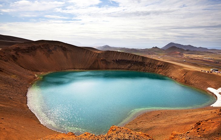
Askja is an active volcano situated in a remote part of the central highlands of Iceland. The name Askja refers to a complex of nested calderas within the surrounding Dyngjufjöll mountains, which rise to 1,510 m, askja meaning box or caldera in Icelandic.
Askja was virtually unknown until the subplinian eruption which started on March 28, 1875, followed by the devastating phreatoplinian explosion on March 29, 1875. Especially in the Eastfjords of Iceland, the ashfall was heavy enough to poison the land and kill livestock. Ash, or tephra from this eruption was wind-blown to Norway, Sweden, Germany and Poland. The eruption triggered a substantial wave of emigration from Iceland. Another less well-known eruption, called Askja-S, occurred in the early Holocene, ca 11,000 years ago. Tephra from this eruption has been found in south-east Sweden, Northern Ireland and north Norway and recently as far south as Romania, which makes it one of the most far-travelled Icelandic tephras. The last eruption of Askja was in 1961.
The region is only accessible for a few months of the year. Being situated in the rain shadow to the northeast of the Vatnajökull glacier, the area receives only about 450 mm of rainfall annually.
6.Dettifoss Waterfall
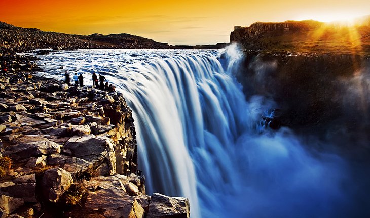
Dettifoss is a waterfall in Vatnajökull National Park in Northeast Iceland, and is reputed to be the second most powerful waterfall in Europe after the Rhine Falls. Dettifoss is situated on the Jökulsá á Fjöllum river, which flows from the Vatnajökull glacier and collects water from a large area in Northeast Iceland.
The falls are 100 metres (330 ft) wide and have a drop of 44 metres (144 ft) down to the canyon Jökulsárgljúfur. It is the second largest waterfall in Iceland in terms of volume discharge (behind the Urriðafoss), having an average water flow of 193 m³/s. The superlative of “most powerful” comes from its water flow times its fall distance. The water of the wide Jökulsá á Fjöllum river falls for more than 44 metres.
On the west bank there are minimal facilities, including a pit toilet, maintained hiking path and a view-platform. On the east bank there is an information panel maintained by the staff of Vatnajökull National Park (Vatnajökulsþjóðgarður), a public toilet, and a trail to the waterfall.
Dettifoss is located on the Diamond Circle, a popular tourist route around Húsavík and Lake Mývatn in North Iceland.
7. Ride to the Top of Hallgrímskirkja
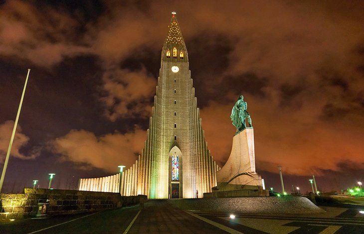
Hallgrímskirkja is a Lutheran parish church in Reykjavík, Iceland. At 74.5 metres tall, it is the largest church in Iceland and among the tallest structures in the country.
Situated on the hilltop Skólavörðuholt near the centre of Reykjavík, the church is one of the city’s best-known landmarks and is visible throughout the city. State Architect Guðjón Samúelsson’s design of the church was commissioned in 1937. He is said to have designed it to resemble the trap rocks, mountains and glaciers of Iceland’s landscape, in particular its columnar basalt “organ pipe” formations (such as those at Svartifoss). The design is similar in style to the expressionist architecture of Grundtvig’s Church of Copenhagen, Denmark, completed in 1940, which has been described as a likely influence, alongside the expressionist Kirche am Hohenzollernplatz in Berlin, Germany (completed in 1933).
The church is also used as an observation tower. An observer can take a lift up to the viewing deck and view Reykjavík and the surrounding mountains.
The statue of explorer Leif Erikson (c.970 – c.1020) by Alexander Stirling Calder in front of the church predates its construction. It was a gift from the United States in honor of the 1930 Althing Millennial Festival, commemorating the 1000th anniversary of the convening of Iceland’s parliament at Þingvellir in 930 AD.