by Best-Mag Magazine Editorial | Travel
Pisa is a city and comune in Tuscany, central Italy, straddling the Arno just before it empties into the Ligurian Sea. It is the capital city of the Province of Pisa. Although Pisa is known worldwide for its leaning tower, the city contains more than twenty other historic churches, several medieval palaces, and bridges across the Arno. Much of the city’s architecture was financed from its history as one of the Italian maritime republics.
The city is also home to the University of Pisa, which has a history going back to the 12th century, the Scuola Normale Superiore di Pisa, founded by Napoleon in 1810, and its offshoot, the Sant’Anna School of Advanced Studies.
The most believed hypothesis is that the origin of the name Pisa comes from Etruscan and means ‘mouth’, as Pisa is at the mouth of the Arno river.
Although throughout history there have been several uncertainties about the origin of the city of Pisa, excavations made in the 1980s and 1990s found numerous archaeological remains, including the fifth century BC tomb of an Etruscan prince, proving the Etruscan origin of the city, and its role as a maritime city, showing that it also maintained trade relations with other Mediterranean civilizations.
Ancient Roman authors referred to Pisa as an old city. Virgil, in his Aeneid, states that Pisa was already a great center by the times described; and gives the epithet of Alphēae to the city because it was said to have been founded by colonists from Pisa in Elis, near which the Alpheius river flowed. The Virgilian commentator Servius wrote that the Teuti founded the town 13 centuries before the start of the common era.
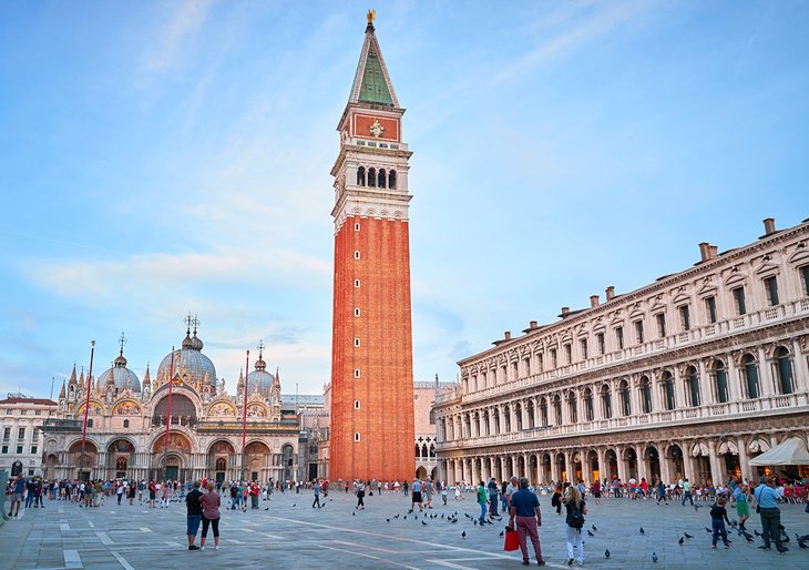
1.The Leaning Tower of Pisa
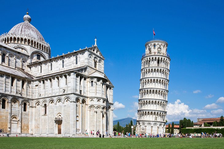
The Leaning Tower of Pisa or simply, the Tower of Pisa is the campanile, or freestanding bell tower, of Pisa Cathedral. It is known for its nearly four-degree lean, the result of an unstable foundation. The tower is one of three structures in the Pisa’s Cathedral Square (Piazza del Duomo), which includes the cathedral and Pisa Baptistry.
The height of the tower is 55.86 metres (183 feet 3 inches) from the ground on the low side and 56.67 m (185 ft 11 in) on the high side. The width of the walls at the base is 2.44 m (8 ft 0 in). Its weight is estimated at 14,500 tonnes (16,000 short tons).The tower has 296 or 294 steps; the seventh floor has two fewer steps on the north-facing staircase.
The tower began to lean during construction in the 12th century, due to soft ground which could not properly support the structure’s weight. It worsened through the completion of construction in the 14th century. By 1990, the tilt had reached 5.5 degrees. The structure was stabilized by remedial work between 1993 and 2001, which reduced the tilt to 3.97 degrees.
Every child has heard of it, and every visitor to Pisa probably heads first to what is undoubtedly the world’s most famous tower: La Torre Pendente, the leaning campanile standing next to the cathedral.
The foundation stone was laid in 1173, when Pisa was Italy’s most powerful maritime republic, and its loggia-like tiers were modeled after the cathedral facade. Even before the third story was completed, the tower had already begun to sink alarmingly on its south side. When counterweighting the north side and slightly increasing the height of the south walls proved ineffective, construction was halted.
Almost 100 years later, work resumed, attempting to counteract the tilt by angling the upper stories more towards the vertical. The open bell-chamber was added to the white marble tower in 1350-72, by Tommaso Pisano.
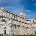
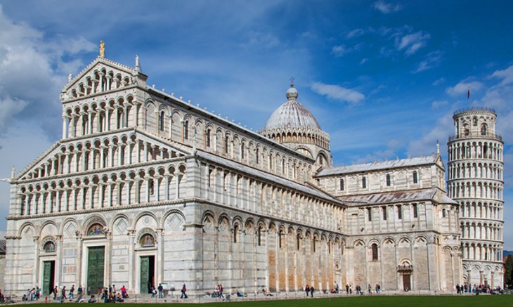
2.Cathedral of Santa Maria Assunta
The Church of Santa Maria Assunta (basilica di Santa Maria Assunta) is a basilica church on the island of Torcello, Venice, northern Italy. It is a notable example of Late Paleochristian architecture, one of the most ancient religious edifices in the Veneto, and containing the earliest mosaics in the area of Venice.
According to an ancient inscription, it was founded by the exarch Isaac of Ravenna in 639, when Torcello was still a rival to the young nearby settlement at Venice.
The original church is believed to have had a nave with one aisle on each side and a single apse on the eastern wall of the cathedral. It’s difficult to tell what the original church was like because very little of it survived the subsequent renovations. Much of the plan of the original church survives as its present form is very similar to the original but the only physical parts that survive are the central apse wall and part of the baptistery that survives as part of the façade of the current church.
The first of two major renovations occurred in 864 under the direction of Bishop Adeodatus II. In this renovation, the two aisle apses that appear today were built. Also, the synthronon that fills the central apse was created and the crypt was placed under it. After this renovation, the cathedral would have resembled the current cathedral more than the original church would have but it is not until after the second and final major renovation that the cathedral appears very similar to its current design.
The definitive example of the Pisan architectural style, the Cathedral of Santa Maria Assunta is a five-aisled Romanesque basilica of white marble designed by Pisan architect Buscheto. Begun in 1063, after Pisa’s naval victory over the Saracens, it was consecrated (still unfinished) in 1118, and towards the end of that century, a new west front was added and the main apse was completed.
3.Campo Santo (Sacred Field)
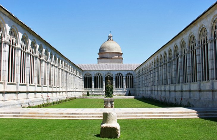
The Campo Santo, also known as Camposanto Monumentale (“monumental cemetery”) or Camposanto Vecchio (“old cemetery”), is a historical edifice at the northern edge of the Cathedral Square in Pisa, Italy.
“Campo Santo” can be literally translated as “holy field”, because it is said to have been built around a shipload of sacred soil from Golgotha, brought back to Pisa from the Third Crusade by Ubaldo Lanfranchi, archbishop of Pisa in the 12th century. A legend claims that bodies buried in that ground will rot in just 24 hours. The burial ground lies over the ruins of the old baptistery of the church of Santa Reparata, the church that once stood where the cathedral now stands.
The term “monumental” serves to differentiate it from the later-established urban cemetery in Pisa.
According to local legend, Archbishop Ubaldo dei Lanfranchi returned from the Fourth Crusade with several shiploads of earth from Golgotha, so that the citizens of Pisa could be buried in sacred soil. The construction of the Camposanto (Sacred Field) to hold it began in 1278, a large rectangular cloister whose gallery of arches decorated with Gothic tracery open into the courtyard.
On the floor of the cloister are the graves of Pisan patricians, and around the sides are Roman sarcophagi. The walls were covered with 14th- and 15th-century frescoes, but a fire caused by artillery bombardment in 1944 melted the lead roof, either destroying or badly damaging the frescoes.
4.Museo dell’Opera del Duomo (Cathedral Museum)
One of the best designed and curated museums in Tuscany is also one of the least-visited places on the Campo dei Miracoli, which is a shame because it adds enormously to an understanding of the art and craftsmanship of that era. And it has an added bonus for those who do explore it: a superb view of the Leaning Tower from the huge second-floor windows.
The cathedral’s museum houses its considerable treasury, which includes priceless masterworks of silversmiths, rich embroideries, tombs, sculpture, and paintings. Many of the sculptures once decorated various buildings of the complex, but were brought indoors for protection many years ago – before they were subject to modern atmospheric pollution, so they are in such good condition that they seem to have been created yesterday instead of centuries ago.
The Museo dell’Opera del Duomo (Museum of the Works of the Cathedral) in Florence, Italy is a museum containing many of the original works of art created for Florence Cathedral, including the adjacent Florence Baptistery and Giotto’s Campanile. Most of the exterior sculptures have been removed from these cathedral buildings, usually replaced by replica pieces, with the museum conserving the originals.
The museum is located just east of the Duomo, near its apse. It occupies the area where much of the sculpture it houses was originally carved, as well as pieces such as Michelangelo’s David, which was commissioned for the cathedral (this is now in the Galleria dell’Accademia).It opened as a museum in 1891, and now houses what has been called “one of the world’s most important collections of sculpture.
5. Murale Tuttomondo
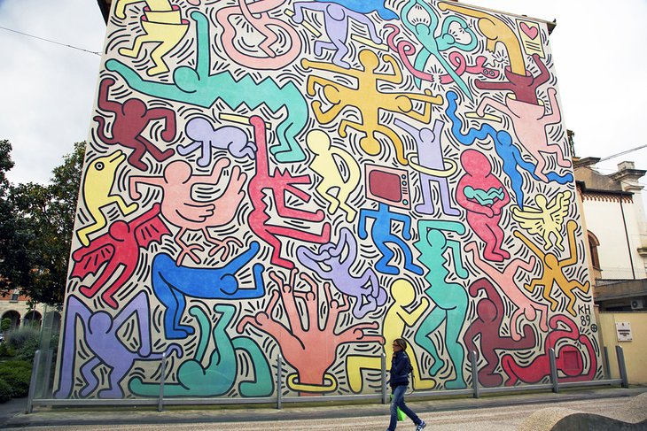
Tuttomondo (English: All World) is a mural created by American artist Keith Haring in 1989. Located on the rear wall of the Sant’Antonio Abate church in Pisa, it is one of the last public murals executed before his death from AIDS-related complications in 1990. It is also one of the few outdoor public works created by Haring for permanent display.
In 1989, after a chance encounter with a student from Pisa, artist Keith Haring was commissioned to paint a mural on the rear wall of Sant’Antonio Abate church. The resulting Tuttomondo (all the world) is one of the largest murals in Europe, at 180 square meters, and took Haring a week to complete.
Tuttomondo is one of only a few outdoor works created by Haring for permanent public display, and he later called it one of his most important. It was also to be one of his last. He completed only one other mural before his death in 1990 at age 31.
Thirty figures, painted in bright colors and in Haring’s cartoon style, seem to tumble across the wall. Women, men, children, a dolphin, a bat, and other animals mix together in an exuberant dance. Haring’s message of harmony and love between humans, animals, and nature is as relevant today as it was in 1989.
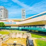
6.Arsenals & Museum of Ancient Ships
The Museum of Ancient Ships is a museum in Pisa, Tuscany, Italy. The museum exhibits ancient ships and artifacts. The exhibition space is within the ancient halls of the Medici Arsenals.
The Arsenals were built between 1548 and 1588 by Grand Duke Cosimo I de’ Medici to strengthen his naval power and revive the glory days of Pisa’s Maritime Republic. The large arcaded sheds were used to build 50-meter-long galleys, warships that were launched directly into the Arno.
The arsenals were built inside the Cittadella, which dates to 1160, but has only the San’Agnese tower still intact. The tall Guelfa Tower (which you can climb for sweeping views across Pisa and the Arno) was built in the early 1400s and rebuilt after World War II damage.
After 1543, the Cittadella was used as artillery barracks and later converted into stables for the Dragon knights, who protected Pisa from Barbary pirates. Today, the arsenal serves as a fitting home for the Museum of Ancient Ships, displaying the exceptional finds from excavations in 1998.
In that year, a construction project unearthed more than 30 ancient ships dating from between the 2nd century BC and the 5th century AD – from the Etruscans to the collapse of the Roman Empire. The grand rooms and aisles built for the Grand Duke’s ships, now display the restored Roman ships and the artifacts found with them, telling of voyages, routes, daily life on board, and shipwrecks.
7.Santa Maria della Spina
Santa Maria della Spina is a small church in the Italian city of Pisa. The church, erected around 1230 in the Pisan Gothic style, and enlarged after 1325, was originally known as Santa Maria di Pontenovo for the newer bridge that existed nearby, collapsed in the 15th century, and was never rebuilt.
The name of della Spina (“of the thorn”) derives from the presence of a thorn, putatively part of the crown of thorns placed on Christ during his Passion and Crucifixion. The relic was brought to this church in 1333. In 1871 the church was dismantled and rebuilt on a higher level due to dangerous infiltration of water from the Arno river. The church was altered in the process, however, and John Ruskin, who visited Pisa in 1872, was outraged about the restoration. The church no longer houses the “thorn”, it is now on display in the Chiesa di Santa Chiara on Via Roma.
The church of Santa Maria della Spina has always been administered by the city,except for short interruptions in the seventeenth and eighteenth centuries when it fell to the responsibility of the local hospital.
The Church of Santa Maria della Spina, on the left bank of the Arno, is perhaps the best known of Pisa’s smaller churches and certainly one of its loveliest. Originally a small oratory sitting right on the river, it suffered severe foundation damage, and in 1871 it was pulled down stone by stone and rebuilt higher up.
The richly ornate Gothic church owes its name to its possession of a thorn (spina) from Christ’s crown of thorns, brought to Pisa from the Holy Land. The west front has two doorways and three distinctive gables, each with a small rose window. On the south side of the church, a series of arches enclose doorways and windows, and higher up, a niche with figures of Christ and the Apostles.
by Best-Mag Magazine Editorial | Travel
Sofia is the capital and largest city of Bulgaria. It is situated in the Sofia Valley at the foot of the Vitosha mountain in the western parts of the country. The city is built west of the Iskar river, and has many mineral springs, such as the Sofia Central Mineral Baths. It has a humid continental climate. Being in the centre of the Balkans, it is midway between the Black Sea and the Adriatic Sea, and closest to the Aegean Sea.
The city’s landmarks reflect more than 2,000 years of history, including Greek, Roman, Ottoman and Soviet occupation. Medieval Boyana Church has 13th-century frescoes. Built by the Romans in the 4th century, St. George Rotunda Church has medieval and Ottoman decoration dating to the 10th century.
Known as Serdica in Antiquity and Sredets in the Middle Ages, Sofia has been an area of human habitation since at least 7000 BC. The recorded history of the city begins with the attestation of the conquest of Serdica by the Roman Republic in 29 BC from the Celtic tribe Serdi. During the decline of the Roman Empire, the city was raided by Huns, Visigoths, Avars and Slavs. In 809, Serdica was incorporated into the Bulgarian Empire by Khan Krum and became known as Sredets. In 1018, the Byzantines ended Bulgarian rule until 1194, when it was reincorporated by the reborn Bulgarian Empire. Sredets became a major administrative, economic, cultural and literary hub until its conquest by the Ottomans in 1382. From 1530 to 1836, Sofia was the regional capital of Rumelia Eyalet, the Ottoman Empire’s key province in Europe. Bulgarian rule was restored in 1878. Sofia was selected as the capital of the Third Bulgarian State in the next year, ushering a period of intense demographic and economic growth.
1.Neo-Byzantine designed St. Alexander Nevsky Cathedral
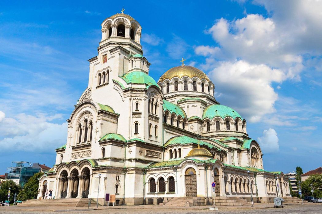
St. Alexander Nevsky Cathedral (Bulgarian: Храм-паметник “Свети Александър Невски”, Hram-pametnik “Sveti Aleksandar Nevski”) is a Bulgarian Orthodox cathedral in Sofia, the capital of Bulgaria. Built in Neo-Byzantine style, it serves as the cathedral church of the Patriarch of Bulgaria and it is one of the 50 largest Christian church buildings by volume in the world. It is one of Sofia’s symbols and primary tourist attractions.St. Alexander Nevsky Cathedral in Sofia occupies an area of 3,170 square metres (34,100 sq ft) and can hold 5,000 people inside. It is among the 10 largest Eastern Orthodox church buildings. It is the largest cathedral in the Balkans. It is believed that up until the year 2000 it was the largest finished Orthodox cathedral.
Considered to be one of the most emblematic sites in Sofia, and one of the most important Orthodox churches in Bulgaria, the St. Alexander Nevsky Cathedral is a sight to step in and see for yourself.
The cathedral was built as a symbol for those who perished during the Russian-Turkish War of 1878-1879, which helped to liberate Bulgaria from the Ottoman Empire.
Be amazed by the beautiful gold-covered domes, and take in the other lavish materials used to give the church its fine details, from Italian marble, Brazilian onyx, and Indian alabaster.
2.Spend the day at the markets of Sofia
Check out the incredible markets that dot the downtown area, and make it a true joy to experience local everyday life in Sofia.
Visit Zhenski Pazar Market, also known as the Women’s Market, known to be the oldest market in Sofia, dating back to the early 20th century.
Find stalls of fresh and local produce brought by local farmers, and smell and taste the authenticity of local dishes sold at the market. It’s a great foodie spot.
Near the famed, Alexander Nevsky Cathedral is the Alexander Nevsky Antiques Market, which is an open-air flea market where visitors can expect everything from soviet union memorabilia, to home goods, and other random yet intriguing second-hand goods.
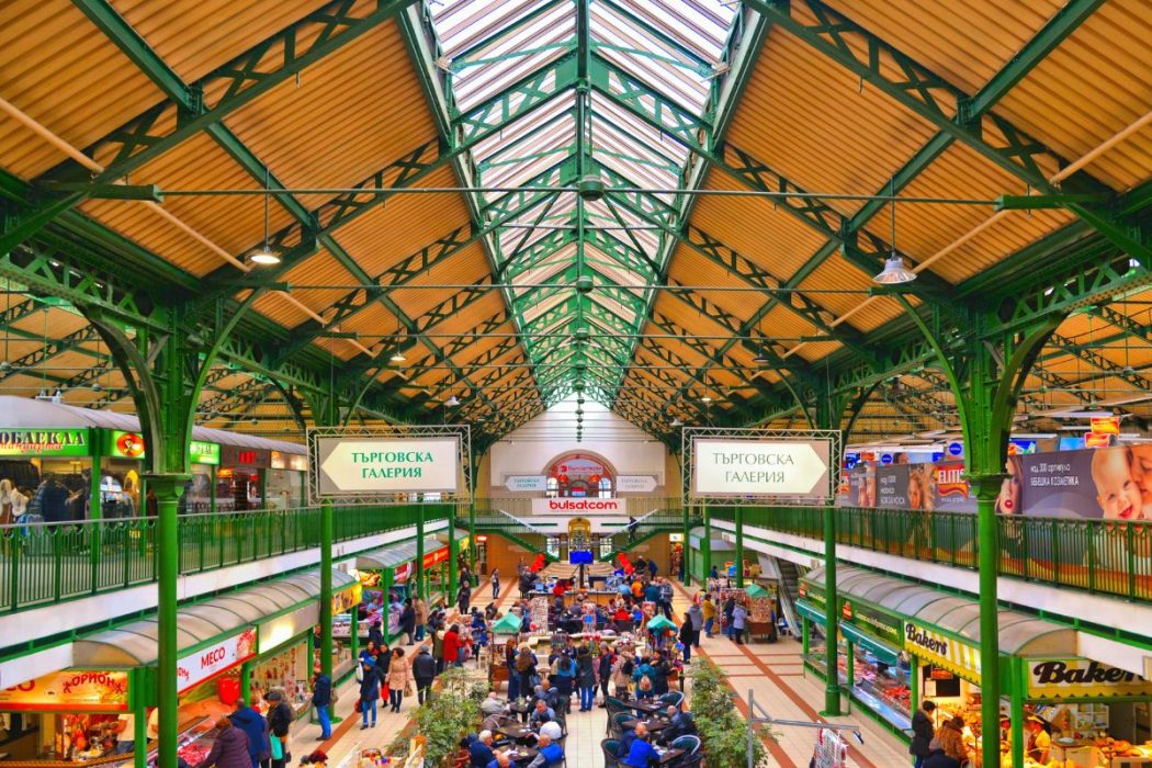
Other markets to visit include the Sofia Central Market Hall and the Bitaka Flea Market.
3.Sofia’s largest museum
The National Historical Museum (Национален исторически музей, Natsionalen istoricheski muzey) in Sofia is Bulgaria’s largest museum. It was founded on 5 May 1973. A new representative exhibition was opened in the building of the Court of Justice on 2 March 1984, to commemorate the 13th centenary of the Bulgarian state. The museum was moved in 2000 to one of the major buildings in the complex serving as official residence of the President, Vice President and Government of the Republic of Bulgaria.[1], and currently contains over 650,000 objects connected to archaeology, fine arts, history and ethnography, although only 10% of them are permanently exhibited.
The museum includes a cloakroom, cafe, library and souvenir shop. It undertakes professional conservation and restoration of historical monuments, authenticity investigations and expert valuation. Its collections comprise materials dating from prehistoric ages till the present.
With over 650,000 exhibits, the National History Museum welcomes visitors to learn more about the fascinating and deep history of Bulgaria, and the capital city Sofia.
From the Bronze Age, and the Middle Ages, all the way to showcasing war relics like uniforms, to everyday textiles, maps, pieces of furniture, and more – the museum will definitely keep all of its visitors for a while as they navigate the different eras of Bulgaria.
Those interested in archaeology will need to visit the archaeological and historical rooms to examine the incredible amount of items found during excavations throughout the country.
4.Visit the Sofia Zoo

Sofia Zoo in Sofia, the capital of Bulgaria, was founded by royal decree on 1 May 1888, and is the oldest and largest zoological garden in Southeast Europe. It covers 36 hectares (89 acres) and, in March 2006, housed 4,850 animals representing 840 species
Spend an afternoon learning about and observing the grand variety of animals that call the Sofia Zoo home, located 12 minutes south of Sofia city center.
With over 2,000 varieties of animals and around 280 represented species, both local and international, children and adult animal enthusiasts will enjoy learning more about each animal, its habitats, and what each animal eats.
Visitors can expect to see animals like otters, goats, lions, bears, lamas, birds of various varieties, and so much more.
Lately, the zoo has opened a new section to the zoo that showcases the study of trees and other wooded plants.
nitially, the zoo was located in the park of the former royal palace, with the primary attraction being a Eurasian black vulture caught in Bulgaria and exhibited in a cage in the garden. Later, pheasants and deer were added to the collection, but since the exhibits and facilities of the time proved inadequate to accommodate a pair of brown bears, Tsar Ferdinand of Bulgaria ordered a grant of land to be awarded to Sofia Zoo on the grounds of the former botanical garden, then in the outskirts of the city.
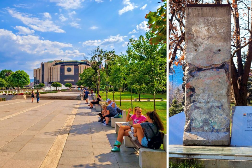
5.Explore the National Palace of Culture
The National Palace of Culture (Национален дворец на културата, Natsionalen dvorets na kulturata; abbreviated as НДК, NDK), located in Sofia, the capital of Bulgaria, is the largest, multifunctional conference and exhibition centre in Southeast Europe. It was opened in 1981 in celebration of Bulgaria’s 1300th anniversary.
The centre was initiated at the suggestion of Lyudmila Zhivkova, daughter of the communist leader of the former People’s Republic of Bulgaria Todor Zhivkov. The project was designed by a team of Bulgarian and foreign architects led by Alexander Georgiev Barov (1931–1999) along with Ivan Kanazirev. The landscaping of Bulgaria Square in front of the National Palace of Culture was designed by another team of architects and landscape engineers, led by Atanas Agura. Internally, the building exhibits a unified style, employing an octagonal motif and heavy, dark colours. Large bright murals depicting historical figures and events cover the main wall of many of the smaller halls.
The National Palace of Culture (NDK) is the largest convention center not only in Bulgaria but in the whole of the southeastern region of Europe.
Built in 1981, the National Palace of Culture estimates that it hosts 300 events per year. It’s located in the heart of Sofia, making it very accessible to visitors.
Most famous for hosting a myriad of events from concerts, to conventions, conferences, exhibitions, festivals, and more, the National Palace of Culture covers approximately 123,000 square meters and towers around 8 stories high.
6.Splish splash at Vazrajdane Aqua Park

Sofia’s very first Aquapark opened in 2020. The brand new swimming complex in the zone B5 to the east of the city, offers 5 outdoor swimming pools, three of which are suitable for children, one pool 140cm deep and one with a hydromassage system. The large green outdoor area with sunbeds and umbrellas (included in the price) offers plenty of outdoor space for safe social distancing.
There is an outdoor bar / cafe restaurant offering
Among the other attractions are an indoor swimming pool and spa centre working year round offering water aerobics, different types of sauna (Finnish and infra red), salt rooms, spa treatments including massage and underwater massage treatments.
Prices for the aquapark are split weekdays before 15:00 18 leva after 15:00 12leva; weekends (& holidays) 24leva / 17leva
Welcoming guests with a refreshing afternoon plan, Vazrajdane Aqua Park, located in the heart of the city, is easily accessed via public transportation on train or bus and it’s one of the best things to do in Sofia with kids.
Stretching over 6,600 square meters and situated inside the extensive Vazrajdane Park, this aqua park offers an incredible amount of relaxing opportunities, as well as exciting and entertaining options.
Fit for everyone in your group, enjoy a large indoor swimming pool and sauna park, as well as fun outdoor swimming pools with twisty slides.
Parents can enjoy the swim-up bar, as well as catching some sun rays on the sunbeds, and enjoy lunch at the restaurant on-site. Indulge further in relaxation with a massage, salt room, tangent baths, and so much more.
7.Roam the streets of Plovdiv – Bulgaria’s second-largest city
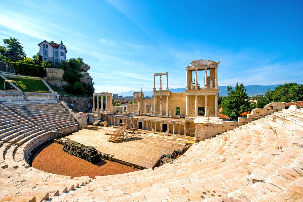
Known as the cultural capital of Bulgaria, Plovdiv is the city famously built around the 7 hills and is recognized nationally and internationally as the oldest continually inhabited European city.In 2019, Plovdiv received the title of European Capital of Culture.Check out the picturesque Ancient Theater, delivering incredible views of the city, made out of marble. Walk through the artsy neighborhood of Kapana, and get a view of the city’s best art pieces inside the abundance of galleries.
We love walking in Plovdiv and have repeatedly recommended that you explore the small intersections. Especially in the center, you may find yourself in Kapana, but there is nowhere to get lost. In the City under the hills, wherever you look, you will come across ancient buildings, quiet courtyards and hidden secrets. And if you need a guide to our favorite Plovdiv streets, look no further. We have selected 6 of them to go around with a camera in your hand and admire the typical atmosphere of the oldest city in Europe.
Well, we have to start with Main Street. Walking in the center is a must, especially on weekends. The street is named Knyaz Alexander Battenberg I, but everyone just calls it Glavnata. Because of its length, it is conditionally divided into two parts – the Small and the Big Main Street. Along with it, besides being able to see the preserved authentic look of buildings from different Bulgarian eras, you will find numerous places for entertainment, food, and drinks. Be sure to look up and don’t miss a single detail, because sometimes the most interesting elements are high above our heads.
by Best-Mag Magazine Editorial | Travel
Marseille, a port city in southern France, has been a crossroads of immigration and trade since its founding by the Greeks circa 600 B.C. At its heart is the Vieux-Port (Old Port), where fishmongers sell their catch along the boat-lined quay. Basilique Notre-Dame-de-la-Garde is a Romanesque-Byzantine church. Modern landmarks include Le Corbusier’s influential Cité Radieuse complex and Zaha Hadid’s CMA CGM Tower.
Marseille is the second most populous city in France, with 870,321 inhabitants in 2020 (Jan. census) over a municipal territory of 241 km2 (93 sq mi). Together with its suburbs and exurbs, the Marseille metropolitan area, which extends over 3,972 km2 (1,534 sq mi), had a population of 1,879,601 at the Jan. 2020 census, the third most populated in France after those of Paris and Lyon. The cities of Marseille, Aix-en-Provence, and 90 suburban municipalities have formed since 2016 the Aix-Marseille-Provence Metropolis, an indirectly elected metropolitan authority now in charge of wider metropolitan issues, with a population of 1,903,173 at the Jan. 2020 census.
Founded c. 600 BC by Greek settlers from Phocaea, Marseille is the oldest city in France, as well as one of Europe’s oldest continuously inhabited settlements. It was known to the ancient Greeks as Massalia (Greek: Μασσαλία, romanized: Massalía) and to Romans as Massilia. The name Massalia probably derives from μᾶζα (mass, lump, barley-cake), the “lump” being the La Garde rock. Marseille has been a trading port since ancient times. In particular, it experienced a considerable commercial boom during the colonial period and especially during the 19th century, becoming a prosperous industrial and trading city. Nowadays the Old Port still lies at the heart of the city, where the manufacture of Marseille soap began some six centuries ago. Overlooking the port is the Basilica of Notre-Dame-de-la-Garde or “Bonne-mère” for the people of Marseille, a Romano-Byzantine church and the symbol of the city. Inherited from this past, the Grand Port Maritime de Marseille (GPMM) and the maritime economy are major poles of regional and national activity and Marseille remains the first French port, the second Mediterranean port and the fifth European port. Since its origins, Marseille’s openness to the Mediterranean Sea has made it a cosmopolitan city marked by cultural and economic exchanges with Southern Europe, the Middle East, North Africa and Asia. In Europe, the city has the third largest Jewish community after London and Paris.
1.Basilique Notre-Dame de la Garde
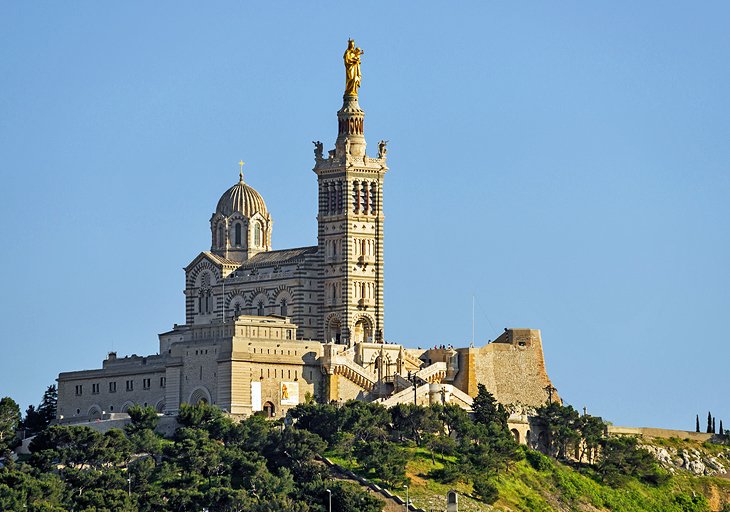
La basilique Notre-Dame de la Garde ou plus simplement Notre-Dame-de-la-Garde, souvent surnommée « la Bonne Mère » (en provençal Nòstra Dòna de la Gàrdia/Nouesto-Damo de la Gardi), est une basilique mineure de l’Église catholique datée du XIXe siècle. Emblème de Marseille, dédiée à Notre-Dame de la Garde (protectrice de Marseille avec saint Victor), elle domine la ville et la mer Méditerranée depuis le sommet de la colline Notre-Dame-de-la-Garde (site classé depuis 19171).
Elle se situe à cheval sur les quartiers du Roucas-Blanc et de Vauban, sur un piton calcaire de 149 m d’altitude surélevé de 13 m grâce aux murs et soubassements d’un ancien fort. Construite par l’architecte protestant Henri-Jacques Espérandieu dans le style romano-byzantin et consacrée le 5 juin 1864, elle remplace une chapelle du même nom édifiée en 1214 et reconstruite au XVe siècle. Bâtie sur les bases d’un fort du XVIe siècle construit par François Ier en 1536 pour résister au siège de Charles Quint, la basilique comporte deux parties : une église basse, ou crypte, creusée dans le roc et de style roman, et au-dessus une église haute de style romano-byzantin décorée de mosaïques. Au sommet d’un clocher carré de 41 mètres de haut surmonté lui-même d’une tourelle de 12,5 mètres qui lui sert de piédestal, se dresse une statue monumentale de 11,2 mètres de la Vierge à l’Enfant réalisée en cuivre doré à la feuille.
Perched on a hilltop above the harbor, this spectacular church is the most important landmark in Marseille. The site was used in ancient times as an observation point, and during the Middle Ages, was the location of a pilgrimage chapel.
Today, the Basilique Notre-Dame de la Garde is a beacon for the faithful, with an enormous gilded Madonna crowning the belfry. Built between 1853 and 1897, the church features an opulent Neo-Byzantine interior of light and dark marble arches supporting gilded mosaic cupolas. The lavish design has a mesmerizing effect.
After seeing the interior, visitors can spend time on the outdoor terrace that offers breathtaking views. The panoramas extend from the red-tile rooftops of Marseille’s buildings to the Vieux Port (historic harbor), all the way to the Frioul Islands in the Mediterranean Sea.
2.Abbaye Saint-Victor
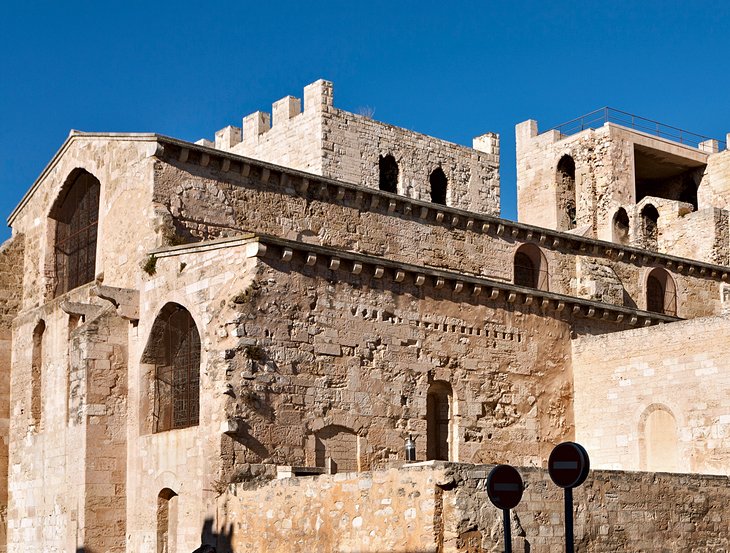
The Abbey of Saint-Victor is a former abbey that was founded during the late Roman period in Marseille in the south of France, named after the local soldier saint and martyr, Victor of Marseilles.
History
The crypts of the abbey contains artefacts indicating the presence of a quarry that was active during the Greek period and later became a necropolis from 2 BC onward until Christian times.
In 415, Christian monk and theologian John Cassian, having come from the monasteries of Egypt, founded two monasteries at Marseille— the Abbey of Saint Victor for men in the south of the Vieux-Port, as well as the Abbey of Saint Sauveur the other for women in the south of Place de Lenche. The Abbey of Saint Victor was later affected during the fifth century by the Semipelagian heresy, which began with some of Cassian’s writings.Both monasteries suffered from invasions by the Vikings and Saracens, and were destroyed in 838 by a Saracen fleet, when the then-abbess Saint Eusebia was also martyred with 39 nuns. In 923, the Abbey of Saint-Victor was destroyed again by the Saracens.
A short walk from the Vieux Port, the Abbaye Saint-Victor is another must-see tourist sight with splendid harbor views.
The Abbaye Saint-Victor was founded in the 5th century and incorporates the original basilica, which makes it one of the oldest buildings in Marseille that is still intact. The basilica, along with its crypt, is considered a gem of Early Christian architecture and art.
Most of the abbey was rebuilt in the 12th and 13th centuries during the Romanesque era. With its crenellated walls and towers, the foreboding exterior has the feel of a medieval fortress.
3.Explore the Vieux Port
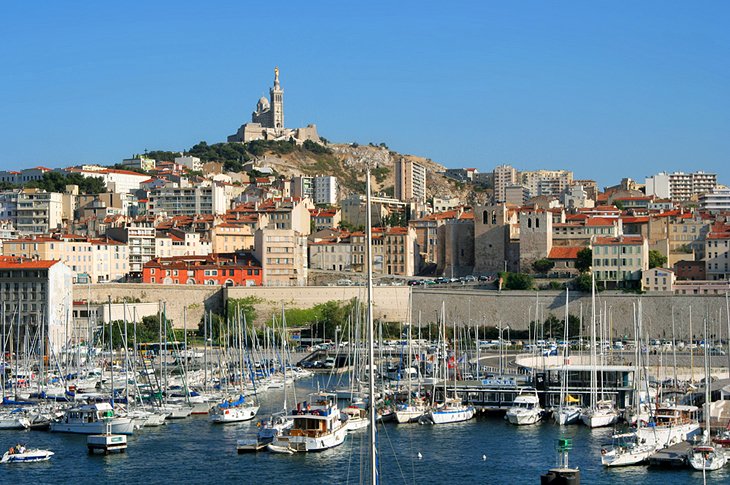
The Old Port of Marseille (French: Vieux-Port de Marseille, [vjøpɔʁ də maʁsɛj]) is at the end of the Canebière, the major street of Marseille. It has been the natural harbour of the city since antiquity and is now the main popular place in Marseille. It became mainly pedestrian in 2013.
The Vieux Port represents the birthplace of Marseille. This is where the city began as a Greek port around 600 BCE. Surrounded by serene blue waters, the Old Port is located in the west of Marseille near La Canebière boulevard.
A stroll around this bustling harbor immerses visitors in the sights and sounds of a thriving Mediterranean port. The waterfront is a focal point for tourists, and many say it’s one of the best places to visit in Marseille for authentic local cuisine. Seafood restaurants specialize in bouillabaisse, the flavorful seafood stew that is the city’s signature dish.
On the east side of the harbor, the Quai des Belges hosts a fish market every morning. Once an important commercial port, the Vieux Port is now used primarily by fishing boats and sports craft.
4.Enjoy Nature Walks and Scenic Boat Tours at Calanques National Park
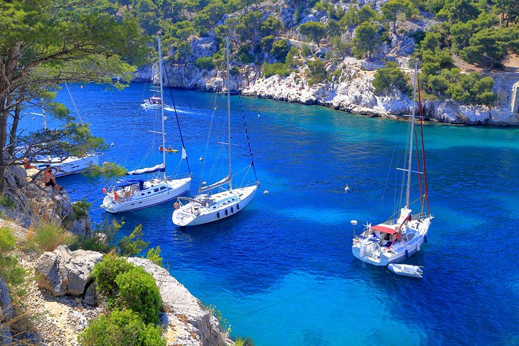
Calanques National Park (French: Parc national des Calanques) is a French national park located on the Mediterranean coast in Bouches-du-Rhône, Southern France. It was established in 2012 and extends over 520 km2 (201 sq mi), of which 85 km2 (33 sq mi) is land, while the remaining is marine area. It includes parts of the Massif des Calanques stretching between Marseille’s southern arrondissements, Cassis and La Ciotat.Some of the park’s best known features include the Calanque de Sormiou, Calanque de Morgiou, Calanque de Port-Miou, Calanque de Sugiton, Calanque d’en Vau and Cosquer Cave.
Between Marseille and the quaint fishing village of Cassis is the Parc National des Calanques, a splendid nature site where the Mediterranean meets the Massif des Calanques mountain range.
The landscape is distinguished by majestic limestone rock walls with fjord-like coves (“calanque” translates to “cove”) filled with pools of saltwater in mesmerizing turquoise hues.
Outdoor sports enthusiasts will find many things to do at Calanques National Park, such as swimming, kayaking, rock climbing, and hiking. An excellent system of trails allows visitors to appreciate the pristine landscape and gorgeous coastal views.
5.Château d’If
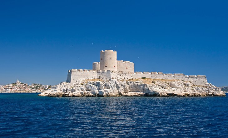
The Château d’If (French pronunciation: [ʃɑto dif]) is a fortress located on the Île d’If, the smallest island in the Frioul archipelago, situated about 1.5 kilometres (7⁄8 mile) offshore from Marseille in southeastern France. Built in the 16th century, it later served as a prison until the end of the 19th century. The fortress was demilitarized and opened to the public in 1890. It is famous for being one of the settings of Alexandre Dumas’s adventure novel The Count of Monte Cristo. It is one of the most visited sites in the city of Marseille (nearly 100,000 visitors per year).
A short ferry ride away from the Vieux Port of Marseille, the Château d’If is located on the Île d’If in the Frioul Islands archipelago, a nature conservation area that includes the tiny islands of If, Pomègues, Ratonneau, and Tiboulen.
The spectacular scenery features protected coves, turquoise waters, pristine beaches, sandy creeks, and impressive limestone cliffs. Thanks to the Mediterranean sunshine, the light creates a serene shimmering effect on the water, and a microclimate allows rare floral species to thrive here.
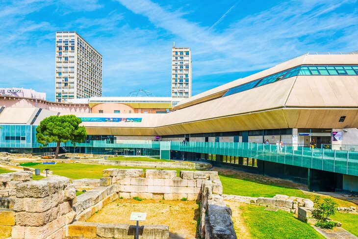
6.Musée d’Histoire de Marseille
Le musée d’Histoire de Marseille est un musée consacré à l’histoire de la ville de Marseille. Fondé en 1983, il a été entièrement rénové et a rouvert le 14 septembre 2013 à l’occasion de Marseille-Provence 2013.
Installé dans le Centre Bourse, à proximité du Vieux-Port, le musée d’histoire de Marseille abrite le site du Port antique, une exposition permanente de 3 500 m2, un espace d’exposition temporaire, un centre de documentation et un auditorium2, ce qui en fait le plus important musée d’histoire urbaine en France
In Le Panier quarter, just a few steps away from the Vieux Port, the Musée d’Histoire de Marseille tells the story of Marseille from its Gallo-Greek origins through the Middle Ages to the present day. The museum offers an impressive collection of artifacts, covering 2,600 years of history.
The historical evolution of France’s oldest city comes to life in this sleek modern museum’s bright spacious rooms. The collections contain 4,000 items and hundreds of multimedia exhibits.
7.La Vieille Charité
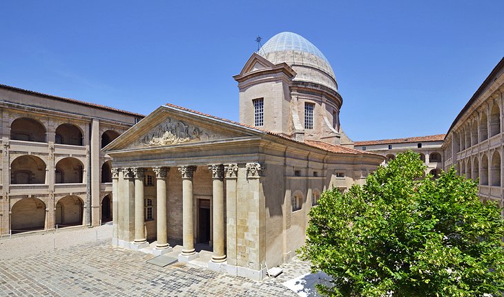
La Vieille Charité is a former almshouse, now functioning as a museum and cultural centre, situated in the heart of the old Panier quarter of Marseille in the south of France. Constructed between 1671, and 1749, in the Baroque style to the designs of the architect Pierre Puget, it comprises four ranges of arcaded galleries in three storeys surrounding a space with a central chapel surmounted by an ovoid dome.
The chapel and the hospice were classified as a historic monument by order of January 29, 1951.
La Vieille Charité is located on the Place des Moulins that lies at the highest point in Le Panier.
The building was created in 1640 when the Town Council of Marseille decided to give impoverished residents decent accommodations, in compliance with a royal policy of “enclosing the poor.”
In 1749, a three-floor public hospital with four wings was added to the building. There is a chapel at the center courtyard of the hospital complex. Built from 1679 to 1707, the chapel is a wonderful example of Italian Baroque architecture.
by Best-Mag Magazine Editorial | Travel
Moscow, on the Moskva River in western Russia, is the nation’s cosmopolitan capital. In its historic core is the Kremlin, a complex that’s home to the president and tsarist treasures in the Armoury. Outside its walls is Red Square, Russia’s symbolic center. It’s home to Lenin’s Mausoleum, the State Historical Museum’s comprehensive collection and St. Basil’s Cathedral, known for its colorful, onion-shaped domes.
Moscow (/ˈmɒskoʊ/ MOS-koh, US chiefly /ˈmɒskaʊ/ MOS-kow;Russian: Москва, tr. Moskva, IPA: [mɐskˈva) is the capital and largest city of Russia. The city stands on the Moskva River in Central Russia, with a population estimated at 13.0 million residents within the city limits,over 18.8 million residents in the urban area, and over 21.5 million residents in the metropolitan area. The city covers an area of 2,511 square kilometers (970 sq mi), while the urban area covers 5,891 square kilometers (2,275 sq mi), and the metropolitan area covers over 26,000 square kilometers (10,000 sq mi). Moscow is among the world’s largest cities, being the most populous city entirely in Europe, the largest urban and metropolitan area in Europe,and the largest city by land area on the European continent.
First documented in 1147, Moscow grew to become a prosperous and powerful city that served as the capital of the Grand Duchy of Moscow. When the Tsardom of Russia was proclaimed, Moscow remained the political and economic center for most of its history. Under the reign of Peter the Great, the Russian capital was moved to the newly founded city of Saint Petersburg in 1712, diminishing Moscow’s influence. Following the Russian Revolution and the establishment of the Russian SFSR, the capital was moved back to Moscow in 1918, where it later became the political center of the Soviet Union.In the aftermath of the dissolution of the Soviet Union, Moscow remained the capital city of the newly established Russian Federation.
1.Marvel at the Size of the Kremlin
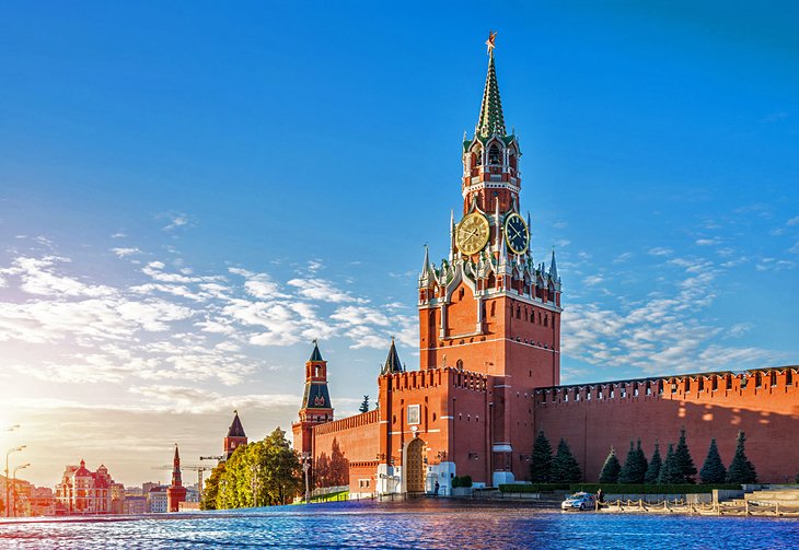
The Moscow Kremlin (Russian: Московский Кремль, romanized: Moskovskiy Kreml’, IPA: [mɐˈskofskʲɪj ˈkrʲemlʲ]), also simply known as the Kremlin, is a fortified complex in the center of Moscow. It is the best known of the kremlins (Russian citadels), and includes five palaces, four cathedrals, and the enclosing Kremlin Wall with Kremlin towers. In addition, within the complex is the Grand Kremlin Palace that was formerly the residence of the Russian emperor in Moscow. The complex now serves as the official residence of the Russian president and as a museum with almost three million visitors in 2017. The Kremlin overlooks the Moskva River to the south, Saint Basil’s Cathedral and Red Square to the east, and Alexander Garden to the west.
The name kremlin means “fortress inside a city”,and is often also used metonymically to refer to the Russian government. It previously referred to the government of the Soviet Union (1922–1991) and its leaders. The term “Kremlinology” refers to the study of Soviet and Russian politics.
The Kremlin is open to the public and offers supervised tours.
Moscow’s most recognizable structure is without a doubt the Kremlin, a 15th-century fortified complex that covers an area of 275,000 square meters surrounded by walls built in the 1400s.
The Grand Kremlin Palace -which has over 700 rooms- was once home to the Tsar family and is now the official residence of the president of the Russian Federation, although most heads of state choose to reside elsewhere.
The massive complex also includes many other buildings, some of which are open to the public and can be visited regularly. Aside from three cathedrals (including one where the Tsars were once crowned) and a number of towers, the Kremlin is also home to the Armory building, a museum holding everything from the royal crown and imperial carriages to the ivory throne of Ivan the Terrible and Fabergé eggs.
2.Catch a Performance at the Bolshoi Theatre
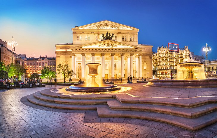
The Bolshoi Theatre (Russian: Большо́й теа́тр, tr. Bol’shoy teatr, IPA: [bɐlʲˈʂoj tʲɪˈat(ə)r], lit. ‘Big Theater’) is a historic theatre in Moscow, Russia, originally designed by architect Joseph Bové, which holds ballet and opera performances. Before the October Revolution it was a part of the Imperial Theatres of the Russian Empire along with Maly Theatre (Small Theatre) in Moscow and a few theatres in Saint Petersburg (Hermitage Theatre, Bolshoi (Kamenny) Theatre, later Mariinsky Theatre and others).
The Bolshoi Ballet and Bolshoi Opera are among the oldest and best known ballet and opera companies in the world. It is by far the world’s biggest ballet company, with more than 200 dancers. The theatre is the parent company of The Bolshoi Ballet Academy, a leading school of ballet. It has a branch at the Bolshoi Theater School in Joinville, Brazil.
The main building of the theatre, rebuilt and renovated several times during its history, is a landmark of Moscow and Russia (its iconic neoclassical façade is depicted on the Russian 100-ruble banknote). On 28 October 2011, the Bolshoi re-opened after an extensive six-year renovation. The official cost of the renovation is 21 billion rubles ($688 million). However, other Russian authorities and other people connected to it claimed much more public money was spent. The renovation included restoring acoustics to the original quality (which had been lost during the Soviet Era), as well as restoring the original Imperial decor of the Bolshoi.
Presently Bolshoi Theatre is under US and EU sanctions and banned from performing in these countries.
The Bolshoi Theater is home to the largest and one of the oldest ballet and opera companies in the world. While the theater has undergone several major renovations over the past century-including a recent one in 2011 to restore some of the imperial architectural details-it still retains all of its Neoclassical grandeur.
The Bolshoi Theater you see today opened in 1824, after several older versions burned down. Inside, red velvet, a three-tiered crystal chandelier, and gilt moldings give the place a Byzantine-Renassaince grandiose feel like no other.
3.Shop at the Luxurious GUM
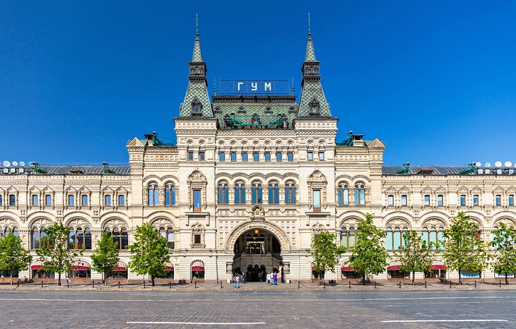
Moscow’s oldest and most upscale shopping center is an architectural marvel. GUM (short for Glávnyj Universálnyj Magazín or “Main Universal Store”) was built in the late 1800s in neo-Russian style to showcase a beautiful mix of a steel skeleton and 20,000 panels of glass forming an arched roof.
This was a unique construction at the time, since the glass had to be strong enough to support the snow-heavy Russian winters. The building is just as impressive outside, with all three levels covered in marble and granite.
While GUM is no longer the largest shopping center in Moscow, it’s still by far the most beautiful. Home to brands like Gucci and Manolo Blahnik, this might not be the ideal destination for most budget-conscious visitors, but the beauty of the building itself is worth a visit.
On the third floor, there are also great dining options, including a Soviet-style canteen that serves traditional Russian food, and a stand selling ice cream made by hand using an original 1954 recipe originally approved by the Soviet government.
4.Make Your Way Into Lenin’s Mausoleum
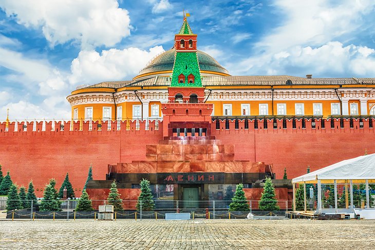
Lenin’s Mausoleum (from 1953 to 1961 Lenin’s and Stalin’s Mausoleum) (Russian: Мавзолей Ленина, tr. Mavzoley Lenina, IPA: [məvzɐˈlʲej ˈlʲenʲɪnə]), also known as Lenin’s Tomb, is a mausoleum located at Red Square in Moscow, Russia. It serves as the resting place of Soviet leader Vladimir Lenin, whose preserved body has been on public display since shortly after his death in 1924, with rare exceptions in wartime. The outdoor tribune over the mausoleum’s entrance was used by Soviet leaders to observe military parades. The structure, designed by Alexey Shchusev, incorporates some elements from ancient mausoleums such as the Step Pyramid, the Tomb of Cyrus the Great and, to some degree, the Temple of the Inscriptions.
Lenin’s Mausoleum, the final resting place of Soviet leader Vladimir Lenin, occupies a central spot in Red Square. His body has been in the mausoleum since his death in 1924-and although the original plan was for him to be buried after a short period of public display for mourning, the plan quickly changed.
After over 100,000 visited the tomb over a period of six weeks, it was decided that a new sarcophagus and a more permanent display space could actually preserve Lenin’s body for much longer than expected-and Lenin’s Mausoleum was built.
5.Spend an Hour (or Three) at Red Square
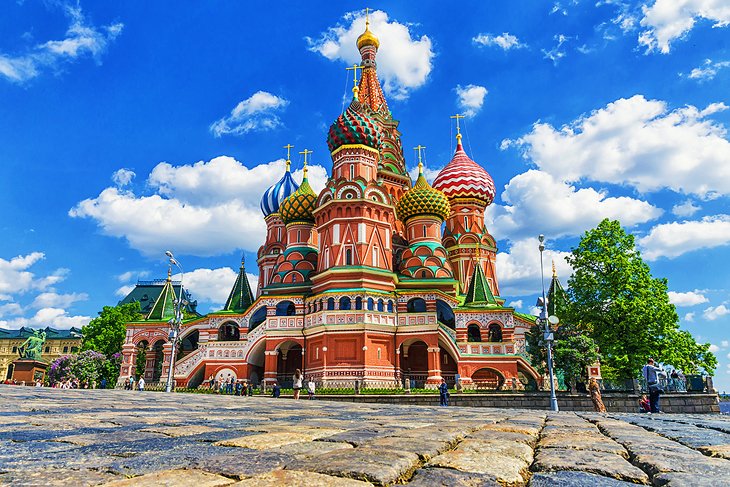
Red Square (Russian: Красная площадь, romanized: Krasnaya ploshchad’, IPA: [ˈkrasnəjə ˈploɕːɪtʲ]) is one of the oldest and largest squares in Moscow, the capital of Russia. It is located in Moscow’s historic centre, in the eastern walls of the Kremlin. It is the city landmark of Moscow, with famous buildings such as Saint Basil’s Cathedral, Lenin’s Mausoleum and the GUM. In addition, it has been a UNESCO World Heritage Site since 1990.
The Red Square has an almost rectangular shape and is 70 meters wide and 330 meters long. It extends lengthways from northwest to southeast along part of the wall of the Kremlin that forms its boundary on the southwest side. In the northeast, the square is bounded by the GUM department store building and the old district of Kitay-gorod, in the northwest by the State Historical Museum and the Resurrection Gate and in the southeast by Saint Basil’s Cathedral. Tverskaya Street begins to the northwest of the square behind the building of the State Historical Museum, and to the southeast is the so-called Basilius slope, which leads to the Moskva River, which goes down and over a bridge to the Zamoskvorechye District. Two streets branch off to the northeast from Red Square: Nikolskaya Street, which is named after the Nikolaus Tower of the Kremlin, which is directly opposite, and the Ilyinka (Ильинка), both of which have existed since the 14th century and were once important arteries of old Moscow. Today the square itself, with the exception of the access road leading through it to the Savior Gate of the Kremlin, is a pedestrian zone.
All of Moscow’s main streets start at Red Square, so it’s easy to see why this is considered the heart of the city. A massive space of 330 meters by 70 meters, the square is flanked by the Kremlin, Lenin’s Mausoleum, two cathedrals, and the State Historical Museum.
6.Ride the Stunning Moscow Metro
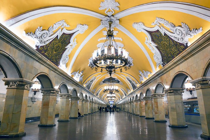
The Moscow Metro is a metro system serving the Russian capital of Moscow as well as the neighbouring cities of Krasnogorsk, Reutov, Lyubertsy and Kotelniki in Moscow Oblast. Opened in 1935 with one 11-kilometre (6.8 mi) line and 13 stations, it was the first underground railway system in the Soviet Union.
As of 2023, the Moscow Metro, excluding the Moscow Central Circle, the Moscow Central Diameters and the Moscow Monorail, had 263 stations (300 with Moscow Central Circle and the Monorail) and its route length was 449.1 km (279.1 mi) (without Moscow Central Circle and the Monorail), making it the 10th-longest in the world and the longest outside China. It is the third metro system in the world (after Madrid and Beijing), which has two ring lines. The system is mostly underground, with the deepest section 84 metres (276 ft) underground at the Park Pobedy station, one of the world’s deepest underground stations. It is the busiest metro system in Europe, the busiest in the world outside Asia, and is considered a tourist attraction in itself.
The Moscow Metro is a world leader in the frequency of train traffic—intervals during peak hours do not exceed 90 seconds. The Moscow Metro is also the first and only one in the world to switch to this schedule. In February 2023, Moscow was the first in the world to reduce the intervals of metro trains to 80 seconds.
Riding the Moscow metro is an experience all in itself, but even just heading underground to walk through the stations is something no visitor should miss. With 223 stations and 12 metro lines crosscutting through Moscow, however, this can be tricky, so visiting at least a few of the most impressive ones is a good start.
Arbatskaya station was designed by a skyscraper architect, so it’s no surprise that it features multicolored granite slabs and impressive bronze chandeliers.
7.Spend a rainy day at the Tretyakov Gallery
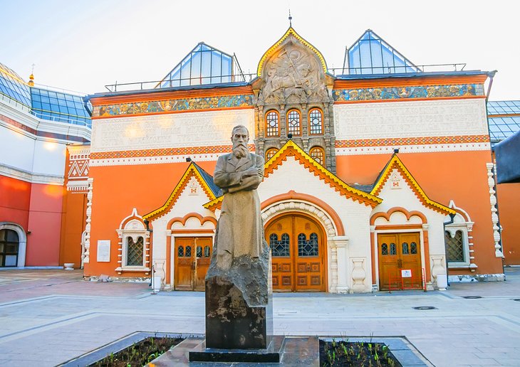
The State Tretyakov Gallery is an art gallery in Moscow, Russia, which is considered the foremost depository of Russian fine art in the world.
The State Tretyakov Gallery (Russian: Государственная Третьяковская Галерея, romanized: Gosudarstvennaya Tretyakovskaya Galereya; abbreviated ГТГ, GTG) is an art gallery in Moscow, Russia, which is considered the foremost depository of Russian fine art in the world.
The gallery’s history starts in 1856 when the Muscovite merchant Pavel Mikhailovich Tretyakov acquired works by Russian artists of his day with the aim of creating a collection, which might later grow into a museum of national art. In 1892, Tretyakov presented his already famous collection of approximately 2,000 works (1,362 paintings, 526 drawings, and 9 sculptures) to the Russian nation. The museum attracted 894,374 visitors in 2020 (down 68 percent from 2019, due to the COVID-19 pandemic). It was 13th on the list of most-visited art museums in the world in 2020.
The largest collection of Russian art in the world sits here, with over 180,000 paintings, sculptures, and religious art dating back to over a millennia ago. The gallery, built using beautiful red and white colors from classical Russian architecture, is located near the Kremlin and it was built in the early 20th century.
Significant art pieces include the Vladimir Mother of God; a Byzantine icon of the Virgin and child dating back to the 1100s; Andrei Rublev’s The Trinity icon from the 15th century; and several works by Ilya Repin, the most famous realist painter in Russia.
by Best-Mag Magazine Editorial | Travel
Venice, city, major seaport, and capital of both the provincia (province) of Venezia and the regione (region) of Veneto, northern Italy. An island city, it was once the centre of a maritime republic. It was the greatest seaport in late medieval Europe and the continent’s commercial and cultural link to Asia. Venice is unique environmentally, architecturally, and historically, and in its days as a republic the city was styled la serenissima (“the most serene” or “sublime”). It remains a major Italian port in the northern Adriatic Sea and is one of the world’s oldest tourist and cultural centres.
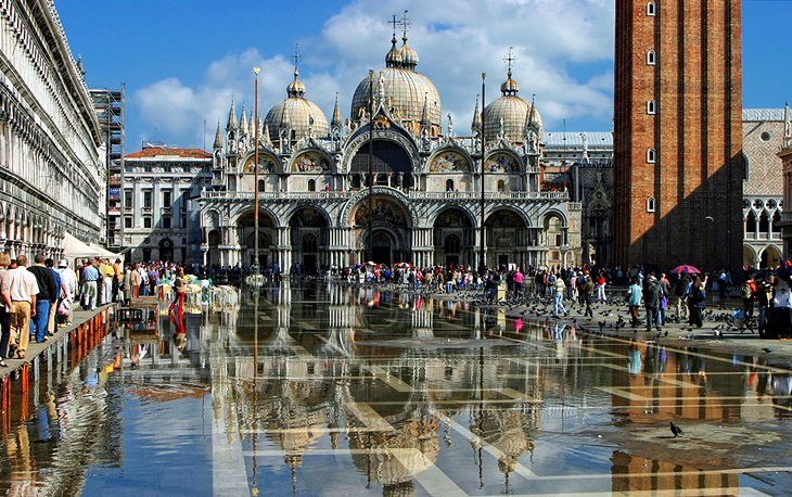
Venice, the capital of northern Italy’s Veneto region, is built on more than 100 small islands in a lagoon in the Adriatic Sea. It has no roads, just canals – including the Grand Canal thoroughfare – lined with Renaissance and Gothic palaces. The central square, Piazza San Marco, contains St. Mark’s Basilica, which is tiled with Byzantine mosaics, and the Campanile bell tower offering views of the city’s red roofs.
1.St. Mark’s Basilica
The Patriarchal Cathedral Basilica of Saint Mark (Italian: Basilica Cattedrale Patriarcale di San Marco), commonly known as St Mark’s Basilica (Italian: Basilica di San Marco; Venetian: Baxéłega de San Marco), is the cathedral church of the Patriarchate of Venice; it became the episcopal seat of the Patriarch of Venice in 1807, replacing the earlier cathedral of San Pietro di Castello. It is dedicated to and holds the relics of Saint Mark the Evangelist, the patron saint of the city.
The church is located on the eastern end of Saint Mark’s Square, the former political and religious centre of the Republic of Venice, and is attached to the Doge’s Palace. Prior to the fall of the republic in 1797, it was the chapel of the Doge and was subject to his jurisdiction, with the concurrence of the procurators of Saint Mark de supra for administrative and financial affairs.
The vast expanse of Venice’s largest square is brought together and made to seem almost intimate by the elegant uniformity of its architecture on three sides. But more than its architectural grace, St. Mark’s Square (Piazza San Marco) is loved as Venice’s living room, the place everybody gathers, strolls, drinks coffee, stops to chat, meets friends and tour guides, or just passes through on the way to work or play.
Three sides are framed in arcades, beneath which are fashionable shops and even more fashionable cafés. The open end is bookmarked by the erratic, exotic curves, swirls, mosaics, and lacy stone filigree of St. Mark’s Basilica.
2.Palazzo Ducale (Doge’s Palace) and Bridge of Sighs
The Doge’s Palace (/doʊ(d)ʒɪzˈpælɪs/; Italian: Palazzo Ducale; Venetian: Pałaso Dogal) is a palace built in Venetian Gothic style, and one of the main landmarks of the city of Venice in northern Italy. The palace was the residence of the Doge of Venice, the supreme authority of the former Republic of Venice. It was built in 1340 and extended and modified in the following centuries. It became a museum in 1923 and is one of the 11 museums run by the Fondazione Musei Civici di Venezia.
Visitors arriving in Venice once stepped ashore under the façade of this extraordinary palace. They couldn’t have failed to be impressed, both by its size and the finesse of its architecture.
If they were received inside by the Doges, the impression would only strengthen as they entered through the Porta della Carta, a perfect example of Venetian Gothic at its height, and ascended the monumental Scala dei Giganti and the gold-vaulted Scala d’Oro to be received in what many consider to be the palace’s most beautiful chamber, Sala del Collegio.
Even jaded 21st-century travelers gasp in awe at the palace’s grandeur and lavish decoration. You’ll see works by all the Venetian greats, including Tintoretto, whose Paradise is the largest oil painting in the world.
In 810, Doge Agnello Participazio moved the seat of government from the island of Malamocco to the area of the present-day Rialto, when it was decided a palatium duci (Latin for “ducal palace”) should be built. However, no trace remains of that 9th-century building as the palace was partially destroyed in the 10th century by a fire. The following reconstruction works were undertaken at the behest of Doge Sebastiano Ziani (1172–1178). A great reformer, he would drastically change the entire layout of the St. Mark’s Square. The new palace was built out of fortresses, one façade to the Piazzetta, the other overlooking the St. Mark’s Basin. Although only few traces remain of that palace, some Byzantine-Venetian architecture characteristics can still be seen at the ground floor, with the wall base in Istrian stone and some herring-bone pattern brick paving.
3.Canale Grande (Grand Canal)
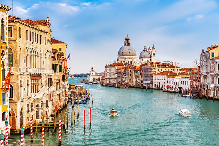
The Grand Canal (Italian: Canal Grande [kaˌnal ˈɡrande]; Venetian: Canal Grando, anciently Canałasso [kanaˈɰaso]) is a channel in Venice, Italy. It forms one of the major water-traffic corridors in the city.
One end of the canal leads into the lagoon near the Santa Lucia railway station and the other end leads into the basin at San Marco; in between, it makes a large reverse-S shape through the central districts (sestieri) of Venice. It is 3.8 km (2.4 mi) long, and 30 to 90 m (98 to 295 ft) wide, with an average depth of 5 metres (16 feet).
The banks of the Grand Canal are lined with more than 170 buildings, most of which date from the 13th to the 18th century, and demonstrate the welfare and art created by the Republic of Venice. The noble Venetian families faced huge expenses to show off their richness in suitable palazzos; this contest reveals the citizens’ pride and the deep bond with the lagoon. Amongst the many are the Palazzi Barbaro, Ca’ Rezzonico, Ca’ d’Oro, Palazzo Dario, Ca’ Foscari, Palazzo Barbarigo and to Palazzo Venier dei Leoni, housing the Peggy Guggenheim Collection.The churches along the canal include the basilica of Santa Maria della Salute. Centuries-old traditions, such as the Historical Regatta [it], are perpetuated every year along the Canal.
Sweeping through the heart of Venice in a giant reverse S curve, the Grand Canal is the principal boulevard through the city, connecting Piazza San Marco, Rialto Bridge, and the arrival points of the rail station and bridge from the mainland.
Only four bridges cross its 3.8-kilometer length, but stripped-down gondolas called traghetti shuttle back and forth at several points between bridges. The Grand Canal was the address of choice for anyone who claimed any influence in Venice. Palaces of all the leading families open onto the canal, their showy Venetian Gothic and Early Renaissance facades facing the water, by which visitors arrived.
4.Ponte di Rialto (Rialto Bridge) and San Polo
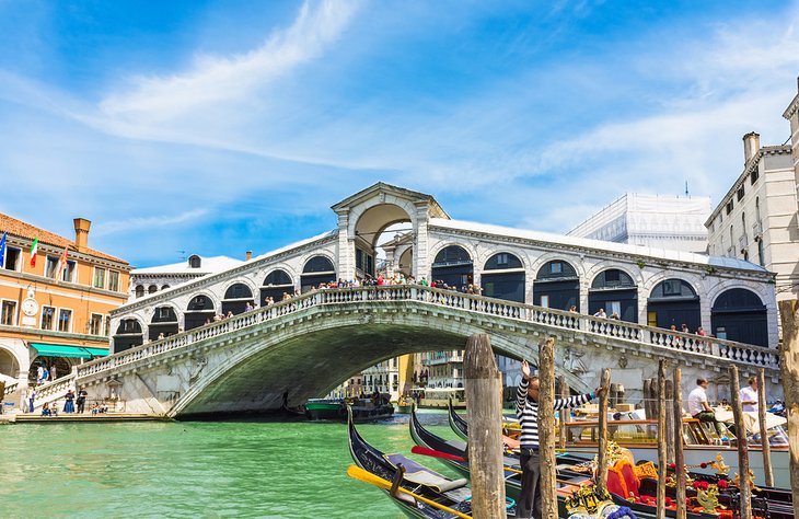
The Rialto Bridge (Italian: Ponte di Rialto; Venetian: Ponte de Rialto) is the oldest of the four bridges spanning the Grand Canal in Venice, Italy. Connecting the sestieri (districts) of San Marco and San Polo, it has been rebuilt several times since its first construction as a pontoon bridge in 1173, and is now a significant tourist attraction in the city.
Once the only bridge across the Grand Canal, Rialto Bridge marks the spot of the island’s first settlement, called Rivus Altus (high bank). Built in 1588, some 150 years after the collapse of a previous wooden bridge, this stone arch supports two busy streets and a double set of shops.
Along with serving as a busy crossing point midway along the canal, it is a favorite vantage point for tourists taking – or posing for – photos, and for watching the assortment of boats always passing under it.
The church of San Bartolomeo, close to the San Marco end of the bridge, was the church of the German merchants who lived and worked in the Fondaco dei Tedeschi (German Commodity Exchange) bordering the canal here. It has an excellent altarpiece, The Martyrdom of St. Bartholomew, by Palma the Younger. The former exchange is now a popular place to go shopping.
5.Torre dell’Orologio (Clock Tower)
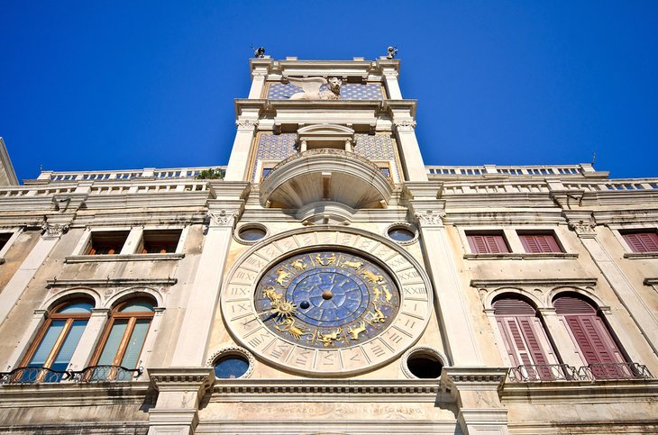
The Clock Tower in Venice is an early Renaissance building on the north side of the Piazza San Marco, at the entrance to the Merceria. It comprises a tower, which contains the clock, and lower buildings on each side. It adjoins the eastern end of the Procuratie Vecchie. Both the tower and the clock date from the last decade of the 15th century, though the mechanism of the clock has subsequently been much altered. It was placed where the clock would be visible from the waters of the lagoon and give notice to everyone of the wealth and glory of Venice. The lower two floors of the tower make a monumental archway into the main street of the city, the Merceria, which linked the political and religious centre (the Piazza) with the commercial and financial centre (the Rialto). Today it is one of the 11 venues managed by the Fondazione Musei Civici di Venezia.
To one side of the basilica, facing onto Piazza San Marco, is one of Venice’s most familiar icons, a clock tower surmounted by a pair of bronze Moors that strike the large bell each hour. The face of the clock shows phases of the moon and the zodiac in gilt on a blue background, and above the clock is a small balcony and a statue of the Virgin.
Above that, the winged Lion of St. Mark and a mosaic of gold stars against a blue background were added in 1755 by Giorgio Massari. The tower itself is from the 15th century and typical of Venetian Renaissance architecture. Through an arched gateway at its base runs one of Venice’s busiest streets, the narrow Calle Mercerei.
6.Campanile
St Mark’s Campanile (Italian: Campanile di San Marco, Venetian: Canpanièl de San Marco) is the bell tower of St Mark’s Basilica in Venice, Italy. The current campanile is a reconstruction completed in 1912, the previous tower having collapsed in 1902. At 98.6 metres (323 ft) in height, it is the tallest structure in Venice and is colloquially termed “el paròn de casa” (the master of the house). It is one of the most recognizable symbols of the city.
Located in Saint Mark’s Square near the mouth of the Grand Canal, the campanile was initially intended as a watchtower to sight approaching ships and protect the entry to the city. It also served as a landmark to guide Venetian ships safely into harbour. Construction began in the early tenth century and continued sporadically over time as the tower was slowly raised in height. A belfry and a spire were first added in the twelfth century. In the fourteenth century the spire was gilded, making the tower visible to distant ships in the Adriatic. The campanile reached its full height in 1514 when the belfry and spire were completely rebuilt on the basis of an earlier Renaissance design by Giorgio Spavento. Historically, the bells served to regulate the civic and religious life of Venice, marking the beginning, pauses, and end of the work day; the convocation of government assemblies; and public executions.
The campanile stands alone in the square, near the front of St Mark’s Basilica. It has a simple form, recalling its early defensive function, the bulk of which is a square brick shaft with lesenes, 12 metres (39 ft) wide on each side and 50 metres (160 ft) tall. The belfry is topped by an attic with effigies of the Lion of St Mark and allegorical figures of Venice as Justice. The tower is capped by a pyramidal spire at the top of which there is a golden weather vane in the form of the archangel Gabriel.
Standing like a giant exclamation point above the expanse of Piazza San Marco, the Campanile is not the first to stand here. The original one, erected as a lighthouse in 1153, collapsed dramatically into the piazza in 1902, and was rebuilt on a firmer footing. Also rebuilt was the Loggetta at its base, a small marble loggia completed in 1540, where members of the Great Council assembled before meeting in the sessions.
In the loggia at the base, you can see Sansovino’s four bronze masterpieces between the columns, all of which were rescued from the rubble after the collapse. The Campanile has a grimmer side to its history: in the Middle Ages, prisoners, including renegade priests, were hoisted halfway up the outside in cages, where they hung suspended for weeks.
7.Santa Maria della Salute
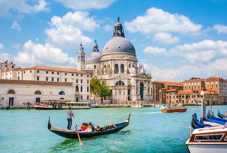
Santa Maria della Salute (English: Saint Mary of Health), commonly known simply as the Salute, is a Roman Catholic church and minor basilica located at Punta della Dogana in the Dorsoduro sestiere of the city of Venice, Italy.
It stands on the narrow finger of Punta della Dogana, between the Grand Canal and the Giudecca Canal, at the Bacino di San Marco, making the church visible when entering the Piazza San Marco from the water. The Salute is part of the parish of the Gesuati and is the most recent of the so-called plague churches.
One of the most photographed churches in Venice, Santa Maria della Salute has a postcard setting, rising at the tip of a peninsula across from the Doge’s Palace.
The monumental Baroque church was built as thanks for the end of the plague of 1630. But the fragile land wouldn’t support its tremendous weight, so its architect, Baldassare Longhena, had more than a million timbers driven into the floor of the lagoon before he could erect the church.
The vaporetto landing is right in front of the church, and the highlight of its interior – apart from the magnificent dome – is the Sacristy, where you’ll find paintings that include Tintoretto’s Marriage at Cana.
by Best-Mag Magazine Editorial | Travel
Brussels is the most densely populated region in Belgium, and although it has the highest GDP per capita, it has the lowest available income per household. The Brussels Region covers 162 km2 (63 sq mi), a relatively small area compared to the two other regions, and has a population of over 1.2 million. The five times larger metropolitan area of Brussels comprises over 2.5 million people, which makes it the largest in Belgium.It is also part of a large conurbation extending towards the cities of Ghent, Antwerp, and Leuven and the province of Walloon Brabant, in total home to over 5 million people.
Brussels grew from a small rural settlement on the river Senne to become an important city-region in Europe. Since the end of the Second World War, it has been a major centre for international politics and home to numerous international organisations, politicians, diplomats and civil servants. Brussels is the de facto capital of the European Union, as it hosts a number of principal EU institutions, including its administrative-legislative, executive-political, and legislative branches (though the judicial branch is located in Luxembourg, and the European Parliament meets for a minority of the year in Strasbourg). Because of this, its name is sometimes used metonymically to describe the EU and its institutions. The secretariat of the Benelux and the headquarters of NATO are also located in Brussels.
As the economic capital of Belgium and a top financial centre of Western Europe with Euronext Brussels, Brussels is classified as an Alpha global city. It is also a national and international hub for rail, road and air traffic, and are sometimes considered, together with Belgium, as the geographic, economic and cultural crossroads of Europe. The Brussels Metro is the only rapid transit system in Belgium. In addition, both its airport and railway stations are the largest and busiest in the country.
1.Saint-Michel Cathedral

The Cathedral of St. Michael and St. Gudula, usually shortened to the Cathedral of St. Gudula or St. Gudula by locals, is a medieval Roman Catholic cathedral in central Brussels, Belgium.
The Cathedral of St. Michael and St. Gudula usually shortened to the Cathedral of St. Gudula or St. Gudula by locals, is a medieval Roman Catholic cathedral in central Brussels, Belgium. It is dedicated to Saint Michael and Saint Gudula, the patron saints of the City of Brussels, and is considered to be one of the finest examples of Brabantine Gothic architecture.
The Romanesque church’s construction began in the 11th century, replacing an earlier chapel, and was largely complete in its current Gothic form by the 16th, though its interior was frequently modified in the following centuries. The building includes late-Gothic and Baroque chapels, whilst its neo-Gothic decorative elements, including some of its stained glass windows in the aisles, date from restoration work in the 19th century. St. Gudula also stands out for its musical components, notably its two pipe organs and its immense church bells. The complex was designated a historic monument in 1936.
2.Visit Mannekin Pis

Manneken Pis has been repeatedly stolen or damaged throughout its history. Since 1965, a replica has been displayed with the original stored in the Brussels City Museum. It is one of the best-known symbols of Brussels and Belgium, inspiring many imitations and similar statues. The figure is regularly dressed up and its wardrobe consists of around one thousand different costumes. Due to its self-derisive nature, it is also an example of belgitude (French; lit. ’Belgianness’), as well as of folk humour (zwanze) popular in Brussels.
Manneken Pis is a landmark 55.5 cm bronze fountain sculpture in central Brussels, Belgium, depicting a puer mingens; a naked little boy urinating into the fountain’s basin.
Along the Rue de l’Etuve is Brussels’ best-known landmark, the Manneken Pis, usually besieged by a throng of tourists.
Although he can be traced back to at least 1388, nothing much is known about the origin of the figure of a little boy urinating, popularly referred to as “the oldest citizen of Brussels.”
The Manneken is, however, surrounded by various legends. According to one, the fountain is a memorial to a courageous infant who averted a conflagration, according to another, it commemorates the son of a count who succumbed to a pressing urge while taking part in a procession.
3.Tour the Place Royale (Koningsplein)
The Place Royale is a historic neoclassical square in the Royal Quarter of Brussels, Belgium. Modelled after the so-called French royal square and built between 1775 and 1782, according to a plan of the architects Jean-Benoît-Vincent Barré and Gilles-Barnabé Guimard, to replace the former Palace of Coudenberg, it was part of an urban project including Brussels Park.
The Place Royale is one of oldest architecturally consistent and monumental public squares, as well as an excellent example of 18th-century urban architecture. Rectangular and symmetrical in shape, it measures 77 by 113 metres (253 by 371 ft)and is entirely paved. In its centre stands an equestrian statue of Godfrey of Bouillon. It is also flanked by the Church of St. James on Coudenberg, as well as some of the main museums in the city.
A favorite attraction for photo-ops, the most important building on this square is the Royal Palace (Palais Royal), which is used by the Belgian royal family as an official residence.
The Belgian flag, flown from the roof, signals the sovereign’s presence, and a ceremonial Changing of the Guard takes place every day at about 2:30pm.
From late July to late August, free guided tours of the palace’s interior, taking in the grand reception rooms and halls, are available.
Surrounding the palace are an ensemble of cultural buildings boasting Neoclassical facade.
4.Enter the Atomium
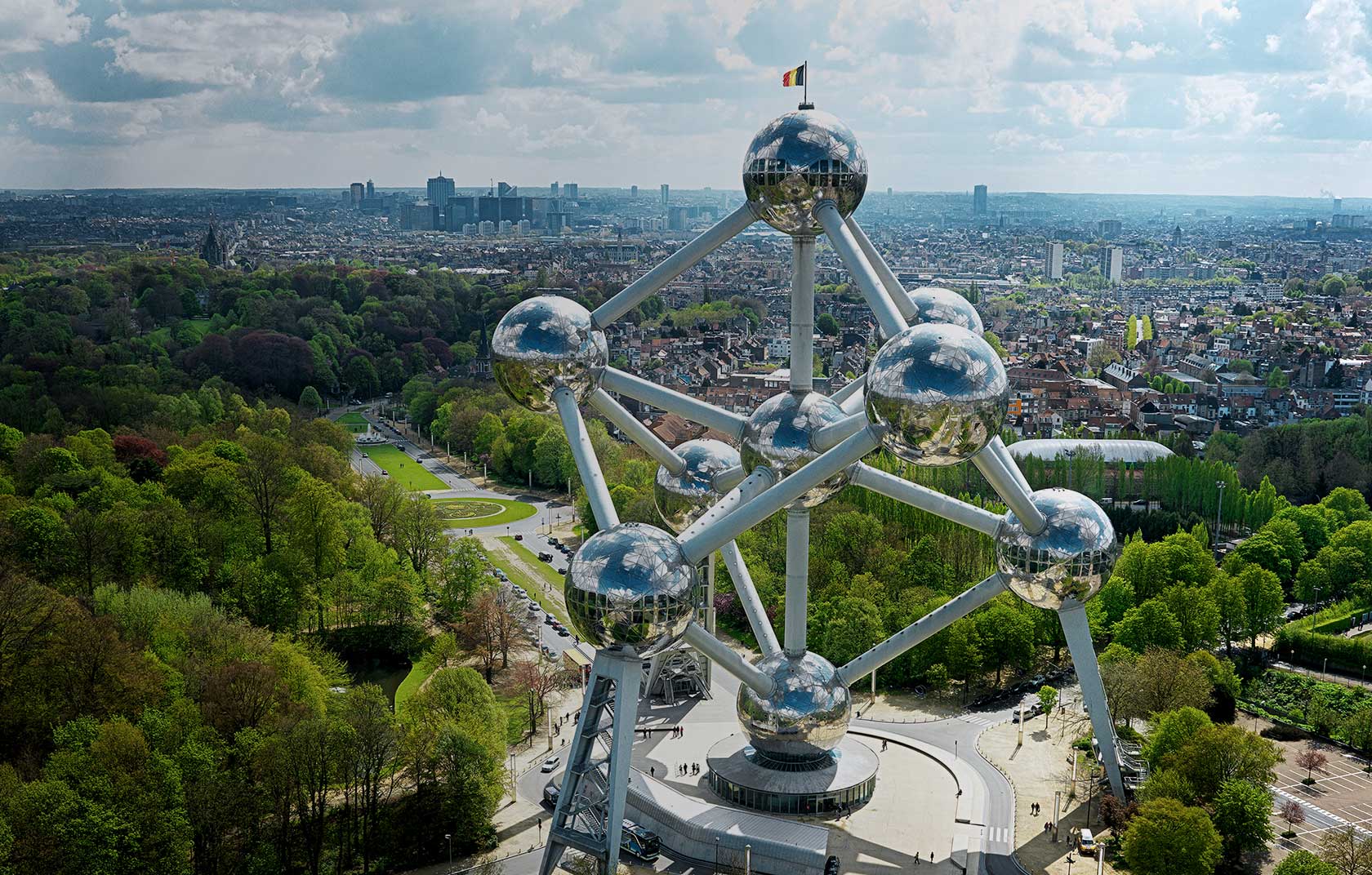
The Atomium is a landmarkmodernist building in Brussels, Belgium, originally constructed as the centrepiece of the 1958 Brussels World’s Fair (Expo 58). Designed by the engineer André Waterkeyn and the architects André and Jean Polak as a tribute to scientific progress, as well as to symbolise Belgian engineering skills at the timeit is located on the Heysel/Heizel Plateau in Laeken (northern part of the City of Brussels), where the exhibition took place. It is the city’s most popular tourist attraction, and serves as a museum, an art centre and a cultural destination.
The Atomium stands 102 metres (335 ft) tall, making it one of the tallest structures in Belgium. Its nine 18-metre-diameter (59 ft) stainless steel clad spheres are connected in the shape of a unit cell that could represent an iron crystal magnified 165 billion times. Steel tubes connecting the spheres enclose stairs, escalators and an elevator (in the central, vertical tube) to allow access to the six visitable spheres, which contain exhibit halls and other public spaces. The top sphere includes a restaurant with a panoramic view of Brussels. The building was completely renovated between 2004 and 2006 by the companies Jacques Delens and BESIX
The Atomium is a landmark modernist building in Brussels, Belgium, originally constructed as the centrepiece of the 1958 Brussels World’s Fair.
Along with Manneken Pis, the Atomium is Brussels’ best-known landmark attraction, and although it’s a bit of a journey by tram to get out here, the bizarre 102-meter-high steel and aluminum structure, designed by the architect André Waterkeyn for the 1958 Brussels World Exhibition, is the city’s most surreal sight.
The building represents a molecule of iron magnified 165 million times.
Today, visitors can enter the building to explore its sci-fi-style interiors. The lower spheres are home to a permanent exhibition on the history of the structure. The upper sphere has incredible panoramas across the city.
5. Coudenberg Palace Archaeological Site
The Palace of Coudenberg was a royal residence situated on the Coudenberg or Koudenberg, a small hill in what is today the Royal Quarter of Brussels, Belgium.
One of Brussels’ most unique things to do is explore this active archaeological site, which was rediscovered in the 1980s.
Coudenberg Palace has been excavated to reveal the cellars and tunnels of the former Palace of Brussels, as well as forgotten streets that had been buried beneath the city for centuries.
The foundations of the medieval palace have been cleared to allow tourists the opportunity to explore, and the museum has free audio guides that take you through the dig site.
For nearly 700 years, the Castle and then Palace of Coudenberg was the residence (and seat of power) of the counts, dukes, archdukes, kings, emperors or governors who, from the 12th century to the 18th century, exerted their sovereignty over the Duchy of Brabant and later over all or part of the Burgundian and then Spanish and Austrian Netherlands.
The palace was completely destroyed in an accidental fire which broke out on the night of 3 February 1731. Only the underground parts remain today. After several years of recent excavations, the archaeological vestiges of the palace and its foundations are open to the public.
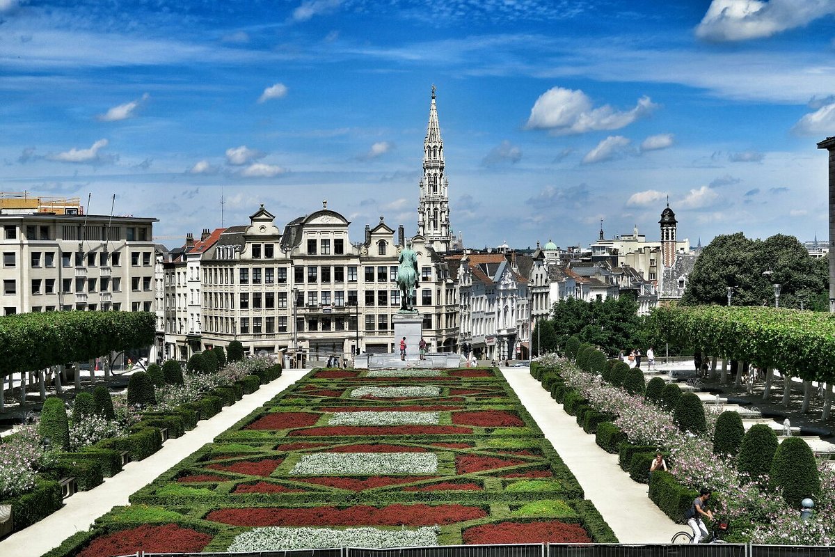
6. Mont des Arts
The Mont des Arts or Kunstberg, meaning “Hill/Mount of the Arts”, is an urban complex and historic site in central Brussels, Belgium, including the Royal Library of Belgium, the National Archives of Belgium, the Square – Brussels Meeting Centre, and a public garden.
The Mont des Arts meaning “Hill/Mount of the Arts”, is an urban complex and historic site in central Brussels, Belgium, including the Royal Library of Belgium (KBR), the National Archives of Belgium, the Square – Brussels Meeting Centre, and a public garden.
This site is located between the Rue Montagne de la Cour/Hofbergstraat and the Place Royale/Koningsplein in its “upper” part, and the Boulevard de l’Empereur/Keizerslaan and the Place de l’Albertine/Albertinaplein in its “lower” part. It is served by Brussels Central Station.
The Mont des Arts was created between 1956 and 1958, occupying the elevated site between the Place Royale and the Place de l’Albertine.
The architecturally imposing complex of large buildings includes the Bibliothèque Albert I and the strikingly modern Palais de la Dynastie and Palais Congrès.
From the square between them is a fine view of the lower central city. The Bibliothèque Albert I was founded during the period of Burgundian rule and comprises more than three million volumes together with a valuable collection of manuscripts and several interesting museums.
7.Meunier Museum
Constantin Meunier (1831-1905) had this beautiful house-cum-studio built towards the end of his life. Sheltering an extensive collection of over 700 works, the house was acquired by the Belgian state in 1936 and opened to the public in 1939. Attached to the Royal Museums of Fine Arts of Belgium, and subsequently renovated, it has since 1986 presented a selection of about 150 works and documents.
The house and studio of Constantin Meunier (1831-1905) is now home to a museum dedicated to his work.
Meunier was a Belgian artist who, in his later paintings and sculptural works, concentrated on a social realist style that was hugely influential on artists throughout the early years of the 20th century. His sculptures of industrial workers are particularly well known.
The museum displays a selection of approximately 150 paintings, drawings, sculptures, and plaster models from its collection of 700, providing an excellent grounding and introduction to Meunier’s work.
The building itself, which Meunier had built towards the end of his life, is a good example of Brussels’ vernacular terraced housing.